A cold front, currently moving through the entire area, will finally break the heat and reduce fire weather concerns, according to the National Weather Service.
A burn ban has been lifted in Wyandotte County, according to fire officials.
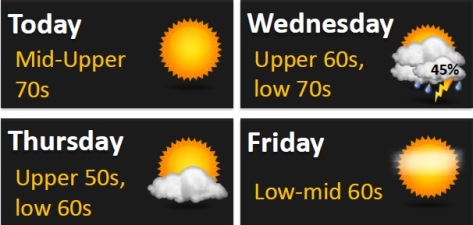
This front will stall though, in southern Missouri, bringing chances of rain and a few storms to east-central Kansas and central Missouri, according to the weather service. The best chances for rain will be along the I-44 corridor. No severe weather is anticipated at this time.
The front will move out of Missouri and Kansas early Thursday leaving clearing skies and highs in the upper 50 and low 60s. The clear, cool weather is expected to stick around for the weekend.
Today, expect sunny skies with a high of 74 in Wyandotte County, the weather service said. A north northwest wind of 5 to 14 mph will gust as high as 20 mph.
Tonight, it will be mostly clear, with a low of 53, the weather service said. There will be a northeast wind of 3 to 6 mph.
Wednesday, skies will be partly sunny with a high near 68, according to the weather service. There will be an east northeast wind of 6 to 8 mph.
Wednesday night, it will be mostly clear with a low of 49, and a north wind of 7 mph, the weather service said.
Thursday, expect mostly sunny skies with a high near 61, the weather service said. There will be a north wind of 8 to 10 mph.
Thursday night, it will be mostly clear with a low of 41, the weather service said.
Friday, expect sunny skies with a high near 66, according to the weather service. Friday night’s weather will be clear with a low of 45.
Saturday, there will be sunny skies with a high near 70, the weather service said. Saturday night, the low will be around 49.
Sunday’s high will be near 73, with sunny skies, according to the weather service.