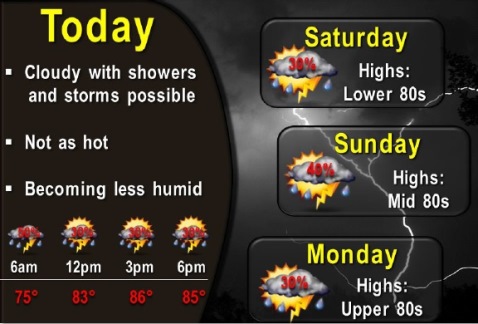
While rain and storms are possible today, the weather will not be as hot, and will become less humid, according to the National Weather Service.
There is a chance for thunderstorms throughout the weekend and into next week, but no severe weather is expected, the weather service said.
Temperatures will climb back to the lower 90s, but at the moment it doesn’t look as hot as this past week, according to the weather service.
At 8:30 a.m. today, there was a storm system to the west of Wyandotte County, according to weather radar.
The forecast for Friday is a 40 percent chance of showers and thunderstorms, with a high near 84, the weather service said. There will be a north wind of 3 to 8 mph.
Tonight, there is a 30 percent chance of showers and thunderstorms, with a low around 68, the weather service said, and a northeast wind of 5 to 7 mph.
Saturday, there is a high near 81 with a 30 percent chance of showers and thunderstorms, according to the weather service, with an east northeast wind of 7 to 9 mph.
Saturday night, expect a 50 percent chance of showers and thunderstorms, with a low of 68, the weather service said. An east northeast wind will be 6 to 8 mph.
Sunday will have a 40 percent chance of showers and thunderstorms, with a high of 84, according to the weather service. An east wind will be 7 to 9 mph.
On Sunday night, there is a 50 percent chance of rain and storms, with a low of 71, according to the weather service.
Monday, there is a 30 percent chance of showers and thunderstorms, with a high of 88, the weather service said.