The excessive heat warning is off for the first day in around a week, and rain moved through portions of the area this morning.
The National Weather Service said cooler weather will move in this week, compared to last week’s heat indices over 100.
Ongong scattered thunderstorms along and south of I-70 this morning will continue to push south by mid-morning, leaving behind a mix of sun and clouds, the weather service said.
Thunderstorm chances will return to the entire area Wednesday through the end of the work week, according to the weather service.
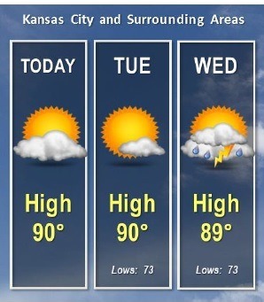
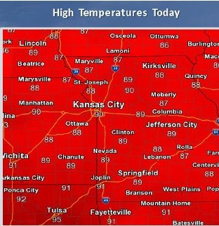
Today, there is a 20 percent chance of precipitation early, with clouds changing to sunny weather later. The high will be near 89, the weather service said. A light northeast wind will become north northeast 8 to 13 mph in the morning.
Tonight, it will be mostly clear, the weather service said, with a low of 72 and an east wind of 6 to 8 mph.
Tuesday, expect mostly sunny skies and a high of 89, according to the weather service. An east wind of 5 to 7 mph will become light and variable in the afternoon.
Tuesday night, the low will be around 73, with an east wind around 6 mph, according to the weather service.
Wednesday, there will be a 40 percent chance of showers and thunderstorms, according to the weather service. The high will be near 90, and there will be an east southeast wind of 3 to 6 mph.
Wednesday night, expect a 50 percent chance of showers and thunderstorms, the weather service said. The low will be around 72.