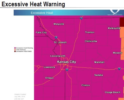
An excessive heat warning continues today in Wyandotte County, and will be in effect through 7 p.m. July 23, according to the National Weather Service.
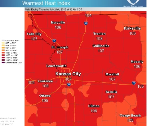
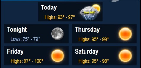
Today, the high will be near 96, with a heat index as high as 106, the weather service said. There will be a light south southwest wind increasing to 8 to 13 mph in the morning.
Don’t expect much relief from the heat until the end of the weekend, according to the weather service.
The chances of thunderstorms this afternoon in the region are small, and severe weather is not anticipated at this time, the weather service said.
The weather service stated that people should take extra precautions if they work or spend time outside today. When possible, reschedule strenuous activities to early morning or evening, wear lightweight and loose-fitting clothing, drink plenty of fluids, stay in an air-conditioned room and out of the sun, and check on relatives and neighbors.
Young children and pets should never be left unattended in vehicles under any circumstances, as the interior of vehicles can reach lethal temperatures in a matter of minutes, according to the weather service.
Tonight, the low will be 78 with a south wind of 9 to 11 mph, according to the weather service.
Thursday, the high will be near 98, with a heat index as high as 109, the weather service said. A south southwest wind of 10 to 16 mph is forecast, with gusts as high as 24 mph.
Thursday night, expect a low of 79, with a south wind of 11 mph, according to the weather service.
Friday may be hotter, with a high near 100, according to the weather service. A south southwest wind of 9 to 13 mph is in Friday’s forecast.
Friday night will have a low of 78, the weather service said.
Saturday, expect a high of 97, according to the weather service.