Thunderstorm chances will increase throughout the day Friday in the region, peaking in the mid to late afternoon, according to the National Weather Service.
A few strong storms will be possible, but widespread severe weather is not expected at this time, the weather service said.
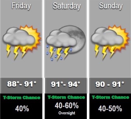
The Wyandotte County forecast says showers and thunderstorms are possible mainly after 11 a.m. Today’s high will be near 90, with a heat index as high as 96, the weather service said. The chance of rain is 40 percent. A tenth to a quarter-inch of rain is possible.
Tonight, expect a 20 percent chance of showers and thunderstorms before 4 a.m., according to the weather service. The low will be around 75, with a south wind of 7 to 9 mph.
Saturday, it will be mostly sunny with a high near 94, and a heat index of up to 99, the weather service said. A south wind of 8 to 14 mph will gust as high as 20 mph.
Another round of thunderstorms will be possible area wide Saturday night into Sunday. These storms bring the potential for heavy rain and potential flooding, mainly north of I-70, the weather service said.
Saturday night, there is a 50 percent chance of showers and thunderstorms, with a low of 75, according to the weather service. A south wind will be 6 to 11 mph. Between a quarter and a half-inch of rain is possible.
Sunday, expect a 30 percent chance of showers and thunderstorms, the weather service said. The high will be near 90, with a southeast wind of 6 mph becoming northwest in the afternoon. Between a tenth and quarter of an inch of rain is expected.
Sunday night’s low will be around 72, the weather service said.
Monday, rain continues in the forecast with a 30 percent chance of showers and thunderstorms, according to the weather service. The high will be near 91.