An excessive heat warning is in effect from 11 a.m. through 9 p.m. today, according to the National Weather Service.
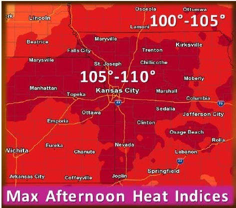
Dangerous heat is expected this afternoon with temperatures soaring into the upper 90s to near 100, the weather service said. Heat indices will range from 100 to 110.
When possible, residents should reschedule strenuous activities to early morning or evening, the weather service said.
Wear lightweight and loose-fitting clothing when possible and drink plenty of water, the weather service said. Check on the elderly, children and pets. Children and pets should never be left unattended in vehicles under any circumstances, the weather service said. In hot weather the interior of a car can reach lethal temperatures in a matter of minutes.
Today, it will be sunny and hot, with temperatures reaching 99 in Kansas City, Kan., with a heat index as high as 108, the weather service said. It will be breezy with a southwest wind of 14 to 20 mph, gusting as high as 28 mph.
Tonight, the low will be around 74, with a southwest wind of 5 to 14 mph becoming north northwest after midnight, according to the weather service. Winds could gust as high as 18 mph.
Thursday, it will be mostly sunny with a high near 91, according to the weather service. A northeast wind will be around 6 mph.
Thunderstorm chances will return Thursday night into Friday, with occasional chances for storms during the weekend. Widespread severe weather is not expected.
Thursday night, there will be a 40 percent chance of showers and thunderstorms, with a low of 70, the weather service said. A northeast wind of 6 mph will become east southeast after midnight.
Friday, expect a 50 percent chance of showers and thunderstorms, according to the weather service. It will be partly sunny with a high near 90 and a south southeast wind of 6 to 9 mph.