Wyandotte County and the surrounding area will be under an excessive heat warning from 11 a.m. today until 8 p.m. Friday, June 17, according to the National Weather Service.
Hot conditions will persist into Thursday and could persist through the rest of the work week, with maximum heat indices on Thursday approaching 110 degrees, the weather service said.
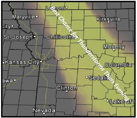
There is a chance of some thunderstorm activity in parts of the region Thursday evening, according to the weather service. An isolated strong storm cannot be ruled out.
The weather service said extreme heat could quickly lead to heat illness or heat stroke if proper precautions are not taken.
The weather service advised to reschedule strenuous activities to early morning or evening. Wear lightweight and loose-fitting clothing when possible and drink plenty of water.
Also, those outdoors working should schedule frequent rest breaks in shaded or air-conditioned environments, according to the weather service. Anyone overcome by heat should be moved to a cool and shaded location. Heat stroke is an emergency and persons should call 911.
Check on relatives and neighbors, the weather service said. Young children and pets should not be left unattended in vehicles under any circumstances, according to the weather services, especially during warm or hot weather when car interiors can reach lethal temperatures in a matter of minutes.
Thursday is an Orange Ozone Alert day, with unhealthy conditions for sensitive groups. Active children and adults, and people with respiratory disease, such as asthma, should limit prolonged outdoor exertion.
Choose more moderate activities. Stay indoors in a building with a good air filtration system, such as a local library, if ozone is especially concentrated or if you are sensitive to air pollution. Schedule activities before 10 a.m. or after 7 p.m.
If you don’t have air conditioning, visit a library, museum or community center.
Check on friends, relatives and neighbors, people with respiratory conditions such as asthma or emphysema, the elderly and children are most affected by air pollution. The heat that generates ozone poses a hazard to them, also.
Limiting car trips or carpooling may help reduce ozone today. RideKC will offer 75-cent bus rides on local and express routes today to promote healthy air quality. Residents should wait until after 7 p.m. to refuel.
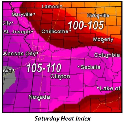
Friday could see heat indices approaching 100 to 110 degrees again, but these temperatures are less certain, depending on thunderstorm activity Thursday evening, the weather service said.
In today’s forecast for Wyandotte County, temperatures may reach a high near 97, with a heat index as high as 107, the weather service said. There is a 20 percent chance of showers and thunderstorms before 1 p.m. There will be a south wind of 3 to 8 mph.
Tonight, the low will be around 75 with a south southeast wind of 5 to 8 mph, according to the weather service.
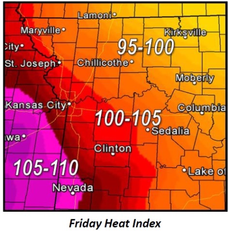
Friday, there will be a 20 percent chance of showers and thunderstorms. The high will be near 95, with a heat index as high as 104, the weather service said. There will be an east wind of 7 to 11 mph.
Friday night, there is a 30 percent chance of showers and thunderstorms, according to the weather service. The low will be 72.
Saturday, it will be mostly sunny with a high near 94, the weather service said, and an east southeast wind of 7 to 10 mph. Saturday night, expect a low of 71.
Sunday’s forecast is sunny with a high near 93, the weather service said, and Sunday night, the low will be around 73.
Monday, expect a high of 93, the weather service said. A 30 percent chance of rain is in Monday night’s forecast.