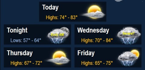
Today will be quieter and drier compared to the last few days, according to the National Weather Service.
However, area rivers, creeks and streams will continue to rise because of the recent rain, the weather service said.
Some storms may pop up again late overnight into the early morning hours on Wednesday, according to the weather service.
For Wednesday, storms could become strong to possibly severe. In addition to cloud-to-ground lightning and moderate to locally heavy rainfall, some storms could contain hail and gusty to perhaps damaging winds, according to the weather service.
Today, the weather will be mostly sunny with a high near 81, the weather service said. Winds will be calm, changing to the south around 5 mph in the afternoon.
Tonight, the low will be around 64. There is a 20 percent chance of thunderstorms and showers after 1 a.m., with patchy fog after 4 a.m., according to the weather service.
Wednesday, showers and thunderstorms are likely mainly after 1 p.m., the weather service said. Patchy fog may be present before 7 a.m. The high will be near 77, with an east southeast wind of 7 to 10 mph becoming southwest in the afternoon. The chance of rain is 70 percent.
Wednesday night, there is a 40 percent chance of showers and storms, the weather service said. The low will be around 54, with a north northwest wind of 8 mph.
Thursday, expect mostly sunny skies and a high of 70, the weather service said. A northwest wind of 7 to 14 mph will gust to as high as 18 mph.
Friday, there is a 30 percent chance of rain, with a high of 73.