Rain started in Wyandotte County about 12:25 p.m. Sunday, and the National Weather Service says to expect rain to continue through Tuesday.
The region is entering into an active weather period with persistent storm chances today through at least Tuesday, the weather service said.
Primary hazards with storms today will be dangerous cloud-to-ground lightning, moderate to locally heavy rainfall, hail, and gusty winds, according to the weather service. Some storms may become strong.
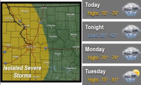
Best chance for isolated severe storms are possible in the area that includes Wyandotte County, according to the weather service.
Today’s high will be near 74, according to the weather service. Between a half and three-quarters of an inch of rain is expected today.
Tonight, there is a 70 percent chance of showers and thunderstorms, mainly before 1 a.m., the weather service said. The low will be around 63. New rainfall amounts of a half to three-quarters of an inch are possible.
Monday, there is a 60 percent chance of rain and storms, mainly after 1 p.m., the weather service said. The high will be near 72. There will be a south wind of 13 to 16 mph, with gusts as high as 24 mph. New rainfall amounts between a quarter and a half-inch are possible.
Monday night, there, is a 50 percent chance of precipitation, with a low of 61, the weather service said.
Tuesday, it will be sunny, with a high near 80, according to the weather service.
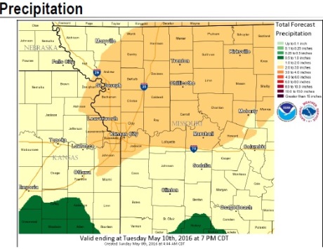
The weather service said from today through Tuesday, widespread rainfall amounts of 1 to 2.5 inches are anticipated, with locally higher amounts possible.
As a result, area rivers, creeks and streams will likely rise again, probably causing flooding issues, according to the weather service.
For the latest weather updates, visit www.weather.gov or listen to a weather radio.