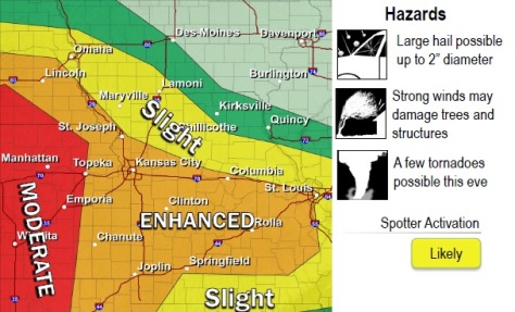
Although skies were sunny at 3 p.m. in Wyandotte County, severe weather is likely tonight in this region, according to the National Weather Service.
There is a 30 percent chance of showers and thunderstorms mainly after 4 p.m. today in Wyandotte County, the weather service said. A south southeast wind of 11 to 14 may gust as high as 20 mph. That precipitation chance increases to 100 percent at 9 p.m. and after, according to the weather service.
A tornado watch is in effect until 3 p.m. until 9 p.m. for Douglas County, Kan., according to the weather service.
A 100 percent chance of showers and thunderstorms is in tonight’s Wyandotte County forecast, after 9 p.m., the weather service said. Between 1 and 2 inches of rain are possible.
All phases of severe weather will be possible tonight, including thunderstorms, winds, hail and tornadoes, according to the weather service. The exact location and times of the severe weather are not yet certain.
At 3:50 p.m., a flash flood watch was issued for later tonight for Wyandotte County and surrounding areas, according to the weather service. It is in effect from 9 p.m. tonight through Wednesday morning.
Localized flooding was reported on Tuesday at locations in Clay and Platte counties in Missouri, the weather service said.
According to the weather service, flooding is expected to occur at Sharp’s Station in Missouri at 9 p.m. Thursday, April 28, and at Platte City, Mo., on Friday morning.
Anyone encountering water in the roadway should turn around and go back, according to the weather service.
Follow developments in the weather at www.weather.gov and on weather radios today.