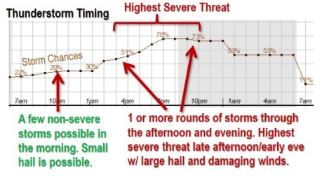
While morning hours may be relatively quiet, with scattered showers and a few non-severe storms, there is a line of strong to severe thunderstorms that could form from mid to late afternoon over eastern Kansas and move eastward.
A separate area of storms may form early this evening further east toward central Missouri.
Large hail is the primary severe threat. Straight-line damage winds are possible with the strongest storms.
There is a low, minimal tornado risk in Wyandotte County. A greater tornado risk is northeast of the Maryville, Mo.
There is likely to be less activity on Thursday morning, and more activity this afternoon over eastern Kansas along a cold front that will advance through Missouri. Forecasters were unsure this morning about the extent and strength of afternoon and evening storms.
The severe risk will likely diminish during the late evening hours. The main hazards appear to be large hail and damaging straight-line winds. In addition, there remains a very small risk for isolated tornadoes.
Today’s high temperature will be 78, with winds from 15 to 21 mph and gusts as high as 29 mph.