There is a 20 percent chance of scattered thunderstorms and rain today in Wyandotte County, however, Wyandotte County is not expected to have any severe weather, according to the National Weather Service.
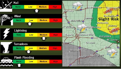
A chance of severe weather will exist over northeast Missouri, generally east of Highway 65. The primary hazards will be large hail and gusty winds. While the tornado threat is low, it cannot be ruled out for that area.
Very high fire danger will develop this afternoon over eastern Kansas into far west central Missouri. Winds will shift from the west and become breezy at 15 to 20 mph by noon, while relative humidity values fall to 30 percent.
The chance of rain and thunderstorms is 20 percent in Wyandotte County after 3 p.m. today, the weather service said. Today’s high will be near 69.
It will be breezy today, with an east northeast wind 7 to 12 mph becoming north northwest 15 to 20 mph in the afternoon, according to the weather service. Winds may gust as high as 29 mph today.
Tonight, there is a 20 percent chance of showers and thunderstorms before 8 p.m., according to the weather service. The low will be around 40. A west wind of 10 to 14 mph may gust as high as 20 mph.
Wednesday, the high will be near 62 with mostly sunny skies, the weather service said. A west northwest wind will be 10 to 14 mph, gusting as high as 20 mph.
Wednesday night, the low will be around 38, with mostly clear skies, according to the weather service. A west wind will be 6 to 11 mph.
Thursday’s forecast is sunny with a high near 60, the weather service said. A west wind will be 9 to 18 mph, with gusts as high as 28 mph.
Thursday night, the low will be 36 with partly cloudy skies, according to the weather service.