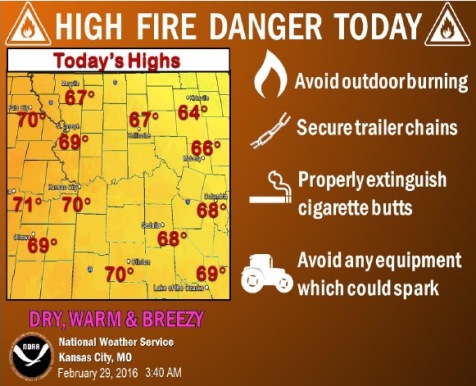
Warm, dry, and breezy south-southwest winds will lead to a high fire danger today, the National Weather Service said.
Outdoor burning is discouraged, extreme care should be taken with open flames and cigarette butts should be properly extinguished, according to the weather service.
Rain may mix with snow across the region to the north Tuesday morning and again on Thursday morning, however little to no accumulation is expected, the weather service said.
Springlike temperatures today will be followed by a cold front moving in on Tuesday, according to the weather service.
Today’s high will be about 69, the weather service said, with a south southwest wind of 13 to 20 mph, gusting to 29 mph.
Tonight, there is a 50 percent chance of rain, mainly after midnight, according to the weather service. The low will be around 37, and it will be windy.
Tuesday, expect a big drop in temperatures, as the high will be near 43, the weather service said. There is a 20 percent chance of rain before noon Tuesday. Winds will be from the north northwest at 14 to 16 mph, gusting as high as 24 mph.
Tuesday night’s low will be around 26, the weather service said.
Wednesday’s high will be near 55, with a south wind from 11 to 16 mph in the morning, gusting as high as 23 mph, according to the weather service.
Wednesday night, there is a 30 percent chance of rain, according to the weather service, with a low of 39.
Thursday, there is a 30 percent chance of rain, with a high near 49, the weather service said.