Temperatures were 61 degrees at 8 a.m. on Friday, Feb. 19, and expected to rise to a high near 70 today, according to the National Weather Service.
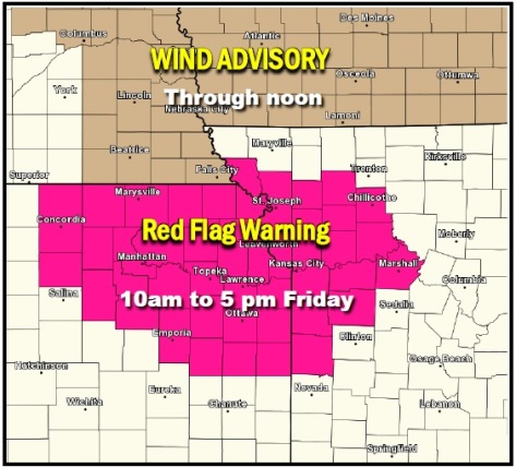
Another red flag warning was issued for Wyandotte County and the region, from 10 a.m. until 5 p.m. today, the weather service said.
The weather service warned of fire danger today and asked residents to refrain from outdoor burning.
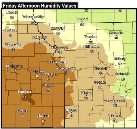
West winds will be significantly weaker on Friday than they were on Thursday. However, humidity values will be quite a bit lower, meaning there is still a fire danger, according to the weather service.
Any fires that develop will likely spread rapidly, the weather service said.
Temperatures will once again rise into the upper 60s and lower 70s.
A west wind today will be from 10 to 18 mph, gusting as high as 28 mph, the weather service said. A low relative humidity of 15 to 20 percent is expected.
Tonight, it will be mostly clear with a low of 46, and a southwest wind of 5 to 8 mph, the weather service said.
Saturday’s forecast is mostly sunny and a high near 70, with a south wind around 5 mph becoming calm in the afternoon, according to the weather service.
Saturday night, the low will be around 43 with a calm wind becoming north around 5 mph after midnight, according to the weather service.
Sunday will be mostly sunny with a high near 58 and a north wind of 5 to 10 mph, the weather service said. Sunday night’s low will be around 33.
Monday, it will be mostly sunny with a high near 48, the weather service said. Monday night’s low temperature will be around 34.
Tuesday, expect mostly cloudy skies with a high near 51, and Tuesday night’s low will be near 31, according to the weather service.