Today’s mild weather will be partly sunny with a high of 64, but rain will be moving into the forecast on Saturday.
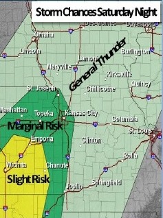
Showers and thunderstorms are expected to overspread the area Saturday, according to the National Weather Service.
A few thunderstorms Saturday night may be strong, capable of producing gusty winds, the weather service said. Saturday’s high will be near 61.
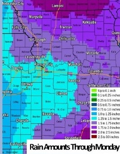
Several rounds of showers and thunderstorms are expected Saturday through Sunday night with widespread precipitation amounts of 1 to 2 inches with locally higher amounts, according to the weather service.
These rainfall totals may be capable of producing flooding along area rivers, creeks, and streams, the weather service said.
Temperatures will drop as the cold front moves through. Sunday’s high will be near 54, the weather service said, and there is a 90 percent chance of rain that day.
Sunday night, temperatures may drop to 36, with a 60 percent chance of rain, according to the weather service.
The work week will start with a cooler day on Monday, a high of 48 and mostly sunny skies, the weather service said. The low Monday night will be about 38.
Tuesday’s high will be a bit warmer, at 53, according to the weather service. Tuesday night, the temperatures may drop to a chilly 31 degrees.
Wednesday’s high will be a bit cooler, at 39 degrees, the weather service said. Wednesday night, the low will be 27.
Thursday’s high will be near 40, according to the weather service.