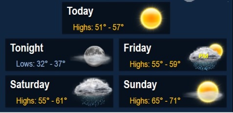
As low temperatures dip back down into the lower to mid 30s tonight, there could be more frost across the area, particularly to the north of the area, according to the National Weather Service.
The next chance for rain arrives late Friday and into Saturday, the weather service said. No severe or other significant hazardous weather is expected.
There will be patchy frost before 9 a.m. on Thursday, Oct. 29. Otherwise, it will be sunny with a high of 54, the weather service said. A light west northwest wind will change to northwest 6 to 11 mph in the morning.
Tonight, expect a low around 36 with a light wind.
Friday, There is a 40 percent chance of showers after 1 p.m., the weather service said. There will be a high near 57.
Friday night, there is a 90 percent chance of showers, with a low around 47. There will be a southeast wind of 3 to8 mph, the weather service said. New rainfall amounts between a quarter and a half-inch are possible, according to the weather service.
On Saturday, there is a chance of showers before 1 p.m., and there will be a high of 59 with cloudy skies, according to the weather service. Light winds will become west 5 to 7 mph in the afternoon. The chance of rain is 40 percent.
On Saturday night, the low will be 44 with partly cloudy skies, according to the weather service.
Sunday will be sunny with a high near 69, according to the weather service.
Sunday night, the low will be around 48, according to the weather service.