Temperatures into the weekend will run around or a few degrees below normal for late October, particularly tonight and tomorrow night, according to the National Weather Service forecast.
Frost will be possible, particularly in sheltered and low-lying spots, and other prone locations, the weather service said.
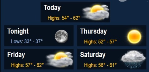
The next chance for rain arrives late Friday into Saturday. No severe or other significant hazardous weather is expected, according to the weather service.
Today, there is patchy fog before 7 a.m., with cloudy skies through mid-morning, the weather service said. Skies will gradually clear, and the high will be near 60. The west northwest wind will be 9 to 16 mph, with gusts as high as 23 mph.
Tonight, there will be patchy frost after 3 a.m., according to the weather service. Otherwise, skies will be mostly cloudy, becoming clear, with a low of 35. The west northwest wind will be 8 mph.
Thursday, look for patchy frost before 9 a.m., along with later sunny skies and a high of 55, according to the weather service. The west northwest wind will be 7 to 10 mph.
Thursday night, it will be mostly clear with a low of 38, the weather service said.
Friday, there is a chance of showers after 1 p.m., according to the weather service. The high will be 59. A light east southeast wind will become southeast 5 to 10 mph in the morning. The chance of rain is 30 percent.
Friday night, there is an 80 percent chance of rain, with a low of 48, the weather service said.
Saturday, there is a 50 percent chance of rain with cloudy skies, according to the weather service.
Saturday night, the low will be 45 with partly cloudy skies, the weather service said.