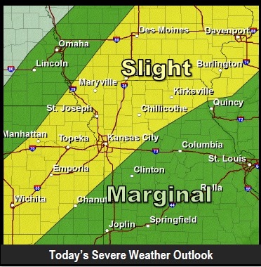
A cold front moving through the region today will bring a risk for strong and severe storms from the afternoon through the early overnight hours, the National Weather Service said.
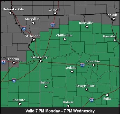
The weather service has issued a flash flood watch for Wyandotte County from 7 p.m. July 6 through 7 p.m. July 8.
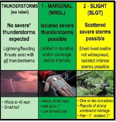
The primary hazards for today’s storms are gusty to potentially damaging winds, dangerous cloud-to-ground lightning, and small hail, according to the weather service.
Showers and thunderstorms are likely, mainly after 4 p.m., when there is a 60 percent chance of rain, according to the weather service. Today’s high will be near 88. The heat index may reach 95, the weather service said. A south wind of 14 to 16 mph is possible, with gusts as high as 24 mph.
Showers and thunderstorms will continue tonight and could produce heavy rainfall, the weather service said. The chance of rain is 90 percent. The low will be 64, with a south wind of 9 to 16 mph, becoming north after midnight. Winds could gust as high as 23 mph, according to the weather service.
Heavy rain, possibly leading to flash flooding, is expected with storms today through at least Wednesday evening, the weather service said.
From 3 to 5 inches of total rainfall is expected along and southeast of a line from Topeka to Kirksville through 7 p.m. Wednesday, according to the weather service.
A widespread 2-3 inches of rainfall are anticipated by Tuesday morning, then up to an additional 2 inches of rain are possible Tuesday through Wednesday evening as several additional rounds of storms develop and move through, the weather service said.
In total, 3-5 inches of rainfall are expected, prompting the issuance of a Flash Flood Watch for the majority of the outlook area.
Rivers, creeks and streams will likely experience flooding with this excessive rainfall, according to the weather service. Residents should not try to cross streets and roads where there is flooding, but should turn around.
Residents are asked to monitor forecasts and be prepared to take action if flash flood warnings are issued. For more weather information, visit www.weather.gov.