Scattered thunderstorms are again expected today, although the highest threat will shift south into southeast Kansas into central Missouri, according to the National Weather Service.
Locally heavy rainfall is possible with these storms, the weather service said. Severe thunderstorms are not expected.
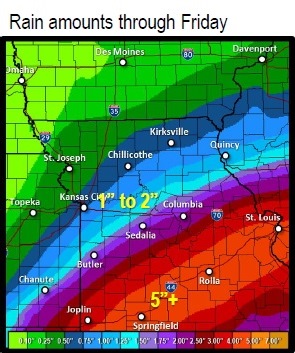
Remnants of Tropical Storm Bill will spread copious amounts of moisture into parts of the region Wednesday through Friday, especially across Oklahoma into the Missouri Ozarks where widespread heavy rain and flooding are possible, according to the weather service.
Some of this heavy rain may make it as far north as Butler, Sedalia and Boonville. Areas further north will miss out on most of this rainfall.
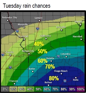
Today, there is a 40 percent chance of showers and thunderstorms, mainly after 1 p.m., the weather service said. Today’s high will be near 79.
Tonight, expect a 50 percent chance of showers and thunderstorms, according to the weather service. The low will be around 69.
The chance of rain and storms is 30 percent on Wednesday, the weather service said. Wednesday’s high will be near 82.
For more weather information, visit www.weather.gov.