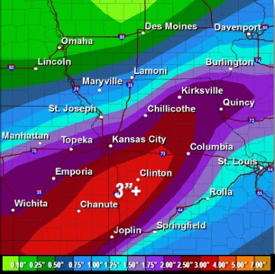
Multiple rounds of heavy rain are possible through the weekend and into early next week with thunderstorms likely throughout the next five days, according to the National Weather Service.
Widespread 2.5-inch amounts are likely with some areas seeing up to 4-inch amounts through Tuesday morning, according to the weather service.
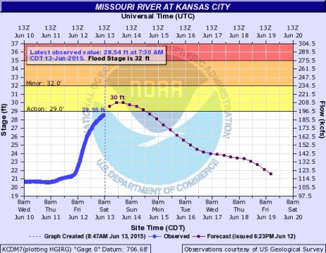
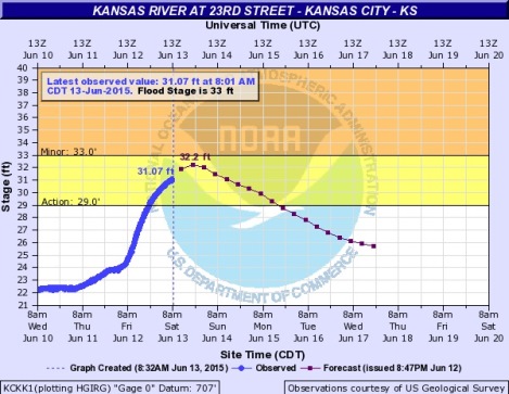
Flash flooding is possible and river flooding will be exacerbated, according to the weather service. The threat for severe thunderstorms is low through the weekend and into early next week.
Today, there is a 60 percent chance of showers and storms before 1 p.m. The high will be near 80, the weather service said.
Tonight, expect an 80 percent chance of showers and storms. The low will be around 68, according to the weather service.
Sunday, the chance of showers and thunderstorms is 60 percent. The high will be near 81, the weather service said.
Sunday night, the chance of rain and storms is 70 percent, with a low of 68, according to the weather service.
Monday, there is a 70 percent chance of showers and thunderstorms, with a high near 80, the weather service said.
For more weather information, visit www.weather.gov.