

Flooding concerns are expected to linger through today in part of the region but as drying occurs and no additional rainfall is expected, the flood threat will diminish, according to the National Weather Service.
However, creeks, streams and rivers will need to be monitored closely as water recedes into these basins, the weather service said.
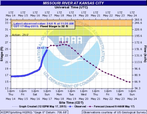
National Oceanic and Atmospheric Administration (NOAA) hydrology charts showed the Missouri River at Kansas City was up to 24.63 feet at 11:30 a.m. May 17 and was predicted to reach 26.4 feet on Monday or Tuesday before receding. Flood stage is 32 feet, and it is predicted to stay under the action stage in Kansas City.
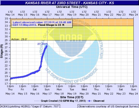
The NOAA hydrology chart for the Kansas River at 23rd Street in Kansas City, Kan., showed the Kaw had reached 27.39 feet at 10:45 a.m. Sunday, May 17. The flood stage is 33 feet and the action stage is 29 feet.
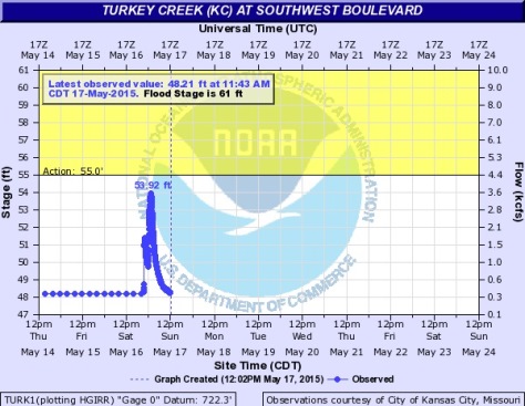
The NOAA hydrology chart for Turkey Creek at Southwest Boulevard showed a reading of 53.92 feet overnight that has now decreased to 48.21 feet as of 11:43 a.m. May 17. Flood stage is 61 feet and the action stage is 55 feet.
After the flood threat has passed, no hazardous weather is expected for the next several days, the weather service said.
Today’s forecast is sunny with a high of 82, according to the weather service. A south southwest wind of 17 to 21 mph may gust as high as 30 mph, the weather service said.
Monday’s forecast is sunny with a high near 70, the weather service said. A north wind of 7 to 14 mph will gust as high as 20 mph.
Tuesday, expect mostly sunny skies and a high of 65. A north northeast wind will be around 10 mph.
Tuesday night, there is a 70 percent chance of rain, the weather service said. The low will be around 50.
Wednesday, there is a 70 percent chance of rain with a high of 57, according to the weather service.
For more weather information, visit www.weather.gov.
