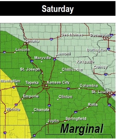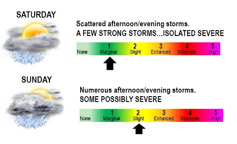
Scattered thunderstorms will pop-up across the region this afternoon, according to the National Weather Service.
A few storms could become strong with small hail, gusty winds, and dangerous lightning being the primary hazards, the weather service said. An isolated severe storm or two cannot be ruled out.
There is a 50 percent chance of rain and storms this afternoon, and the risk increases to 60 percent later tonight, according to the weather service. Some forecasters are saying that there is very little chance of severe weather today; however, lightning could be a threat. There also is a good chance of lightning missing Wyandotte County tonight.
Today’s high was predicted near 75, with an east wind around 11 mph, the weather service said. Tonight’s low was expected to be 65 degrees, with a southeast wind of 14 to 18 mph, gusting to 28 mph, according to the weather service.
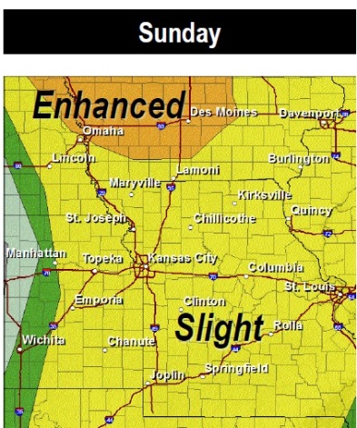
Additional storms are expected Sunday, according to the weather service.
The threat on Sunday will be conditional on whether the airmass can recover from morning storms and become unstable. If it does, severe storms with large hail and damaging winds will be the primary threats, according to the weather service.
For current weather information, visit www.weather.gov.