Scattered showers and isolated thunderstorms overspread eastern Kansas into western Missouri this morning, the National Weather Service said.
Much of this activity gradually weakened as it progressed eastward, according to the weather service.
Additional thunderstorms may develop later this afternoon into tonight, forecasters said. A couple of these storms later today may be strong.
This afternoon’s high will be 78 degrees, with a south wind of 17 to 21 mph, gusting as high as 29 mph, according to the weather service.
Additional rounds of thunderstorms are expected Friday into the weekend, the weather service said.
Some of these storms will have the potential to be strong to severe, according to the weather service. The greatest severe weather potential will exist on Sunday, with all forms of severe weather possible, the weather service said.
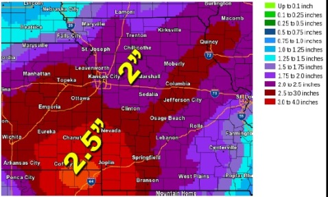
Widespread rainfall in excess of two inches will be possible through early next week, with locally higher amounts, according to the weather service.
The entire area will see the potential for severe weather on Sunday as a cold front and strong upper system moves through, the weather service said.
For more weather information, visit www.weather.gov.

