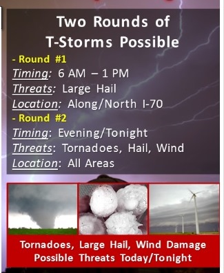
Severe weather will be possible today and tonight across much of the area, according to the National Weather Service.
There is a dense fog advisory now in effect until 11 a.m. on Wednesday in the region, weather service said.
Residents are advised to slow down, use their headlights, and leave plenty of distance ahead of them in the fog.
Strong storms are possible this morning with large hail threatening, the weather service said. Most of the morning risk has already left the area.
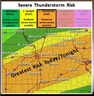
Another round of severe storms is expected this afternoon, after 5 p.m., with a threat for large hail, damaging winds and isolated tornadoes, especially for areas along and south of a line from the northern Kansas City metro area to Kirksville, Mo., according to the weather service.
Additional strong to severe storms are possible early Thursday afternoon, the weather service said.
Today’s high will be near 78. An east wind of 7 to 15 mph will become south in the afternoon, according to the weather service. Winds could gust as high as 22 mph. The chance of rain is 60 percent. Between a quarter and half-inch is possible, the weather service said.
Tonight, showers and thunderstorms are possible mainly before 1 a.m. The low will be 62, with a south wind of 14 to 17 mph and gusts as high as 26 mph, according to the weather service. The chance of rain is 80 percent.
On Thursday, there is a chance of showers and thunderstorms before 1 p.m., then a slight chance of showers, according to the weather service. The high will be near 69. A south southwest wind of 13 to 18 mph will become west northwest in the afternoon, the weather service said, with wind gusts of up to 28 mph. The chance of rain is 40 percent.