Areas of dense and freezing fog were seen in Wyandotte County this morning, with visibility reduced to a quarter mile or less, according to the National Weather Service.
A dense fog advisory was in effect for the area through 11 a.m. Sunday.
Freezing fog can result in a light glaze of ice, the weather service said.
Motorists should slow down, leave plenty of space ahead of them, take their time and drive slowly, according to the weather service.
Watch for slick spots on bridges and elevated surfaces, the weather service said.
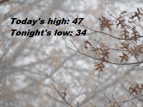
Today there is a widespread dense fog, mainly before noon, the weather service said. A dense freezing fog is possible before 10 a.m. The high will be near 47 with a southeast wind of 3 to 6 mph.
Tonight, there is a patchy fog possible between 10 p.m. and 5 a.m., according to the weather service. The low will be around 34 with a southeast wind of 5 to7 mph.
Monday, there is a 20 percent chance of rain after noon, with a patchy fog between 9 a.m. and 10 a.m., the weather service said. The high will be near 49 with an east southeast wind of 7 to 15mph, gusting as high as 24 mph.
Monday night, there is a 90 percent chance of rain with thunderstorms, also possible after 3 a.m., according to the weather service. The low will be around 44 with a southeast wind of 15 mph, gusting as high as 31 mph. Between a quarter and half-inch of rain is possible.
Tuesday, there is another 90 percent chance of rain with a high near 57 and a southeast wind of 13 to 17 mph becoming south southwest in the afternoon, the weather service said. Winds may gust up to 38 mph. From a half to three-quarters of an inch of rain is possible.