
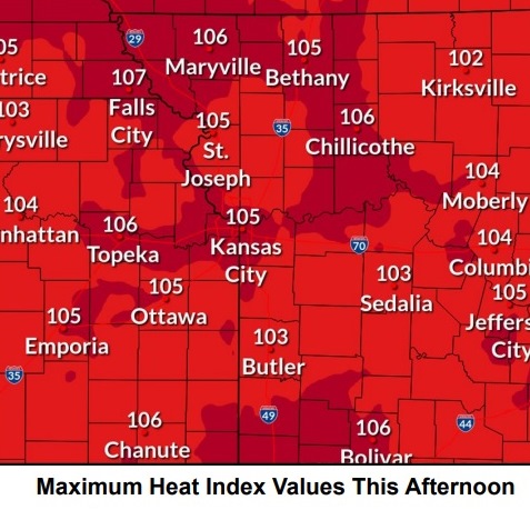
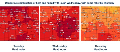
Today’s temperatures may reach 99 today with a heat index as high as 107, according to the National Weather Service. A heat advisory is in effect through 7 p.m. Wednesday.
Temperatures were 83 degrees at 9 a.m. Tuesday, the weather service said.
The heat index could reach 106 on Wednesday before storms move in.
Scattered thunderstorms are expected along a cold front Wednesday into Wednesday night, and a few storms could be strong with gusty winds, according to the weather service.
The weather service advised residents to drink plenty of fluids, stay in an air-conditioned room, stay out of the sun and check on relatives and friends. Young children and pets should not be left unattended in vehicles.
Those who work or spend time outside should take extra precautions, according to the weather service. When possible reschedule strenuous activities to early morning or evening. Wear lightweight and loose-fitting clothes, the weather service said. When working outdoors, schedule frequent rest breaks in shaded or air-conditioned places. Anyone overcome by heat should be moved to a cool and shaded location, and 911 may be called for heat stroke.
Today, it will be sunny and hot, with a high near 99 and heat index as high as 107, the weather service said. A south southwest wind of 11 to 13 mph will gust as high as 23 mph.
Tonight, it will be mostly clear, with a low of 79 and a south wind of 10 to 13 mph, gusting as high as 31 mph, according to the weather service.
Wednesday, there is a 40 percent chance of showers, mainly after 1 p.m., the weather service said. The high will be near 96 with a heat index as high as 106. A south southwest wind of 8 to 13 mph will gust as high as 28 mph. Less than a tenth of an inch of rain is possible.
Wednesday night, there is a 60 percent chance of showers and possibly a thunderstorm before 1 a.m., then a chance of showers and thunderstorms after 1 a.m., according to the weather service. The low will be around 72 with a northeast wind of 6 mph becoming calm in the evening. Between a tenth and quarter-inch of rain is possible.
Thursday, it will be sunny, with a high near 91 and a calm wind becoming northeast 5 to 8 mph in the morning, the weather service said.
Thursday night, it will be mostly clear, with a low of 70, according to the weather service.
Friday, it will be sunny, with a high near 94, the weather service said.
Friday night, it will be mostly clear, with a low of 75, according to the weather service.
Saturday, it will be sunny and hot, with a high near 98, the weather service said.
Saturday night, it will be mostly clear, with a low of 76, according to the weather service.
Sunday, it will be mostly sunny, with a high near 96, the weather service said.
Sunday night, it will be partly cloudy, with a low of 75, according to the weather service.
Monday, it will be mostly sunny, with a high near 95, the weather service said.