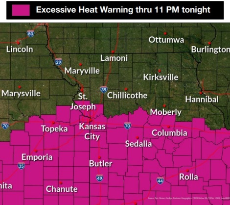
An excessive heat warning is in effect through 11 p.m. Thursday, according to the National Weather Service.
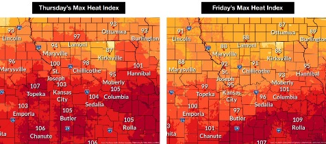
The heat index may reach as high as 102 in Wyandotte County, with a high temperature near 92 on Thursday, the weather service said.
Some areas of the region will see lingering cloud cover, keeping the temperature and heat index slightly cooler, according to the weather service.
Some parts of Wyandotte County received a little rain Thursday morning. Some storms were possible during the morning hours Thursday, the weather service said, and more rain and storms are possible after 5 p.m.
Storms could be strong to severe at times, with wind the main hazard, followed by small hail. Some flash flooding and area flooding is possible.
Storms also are possible Friday morning, with wind and hail the main hazards, according to the weather service. Friday’s forecast also shows a chance of showers and storms after 1 p.m. in Wyandotte County.
Temperatures will drop to a high of 88 on Friday, then are forecast to be near 86 on Saturday, the weather service said.
Sunday’s high will see an increase to 91, with Monday’s high near 96, according to the weather service.
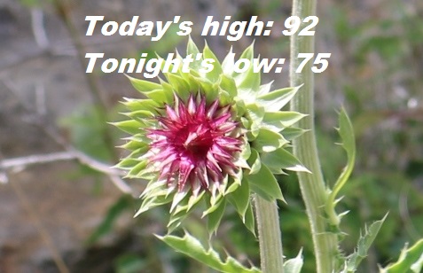
Today, there is a 30 percent chance of showers and thunderstorms before noon, then a slight chance of showers and thunderstorms after 5 p.m., the weather service said. The high will be near 92 with a heat index as high as 102. An east wind of 5 to 8 mph will become south in the afternoon. Less than a tenth of an inch of rain is possible.
Tonight, there is a 30 percent chance of showers and thunderstorms, mainly after 7 p.m., according to the weather service. The low will be around 75 with a south wind of 7 mph becoming west after midnight. New rainfall amounts between a quarter and half-inch are possible.
Friday, there is a 30 percent chance of showers and thunderstorms, mainly after 1 p.m., the weather service said. The high will be near 88 with a heat index as high as 95. A northwest wind will be 5 to 9 mph. Less than a tenth of an inch of rain is anticipated.
Friday night, it will be partly cloudy, with a low of 70 and a north northeast wind of 5 to 7 mph, according to the weather service.
Saturday, it will be mostly sunny, with a high near 86 and a northeast wind of 6 to 8 mph, the weather service said.
Saturday night, it will be mostly clear, with a low of 68, according to the weather service.
Sunday, it will be sunny, with a high near 91, the weather service said.
Sunday night, it will be mostly clear, with a low of 71, according to the weather service.
Monday, it will be sunny, with a high near 96, the weather service said.
Monday night, there is a 30 percent chance of showers and thunderstorms after 1 a.m., with a low of 71, according to the weather service.
Tuesday, it will be mostly sunny, with a high near 91, the weather service said.
Tuesday night, it will be mostly clear, with a low of 68, according to the weather service.
Wednesday, it will be mostly sunny, with a high near 89, the weather service said.