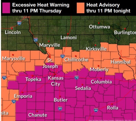
An excessive heat warning is in effect through 11 p.m. Thursday, July 7, according to the National Weather Service.
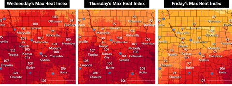
The heat index may range from 103 to 109 through Thursday in the region, the weather service said.
In Wyandotte County, today’s high will be near 97 with a heat index as high as 107, according to the weather service.
Storms and rain are possible tonight, with a 20 percent chance of precipitation, the weather service said.
More hot weather is possible on Thursday, when the high may be near 94 with a heat index of 102, the weather service said.
More storms move in on Thursday and Friday, and the high on Friday will drop to 87, according to the weather service.
There will be two days of highs in the upper 80s before temperatures climb to 92 on Sunday, and Monday’s high temperature will be 95, the weather service said.
Today, residents are advised to drink plenty of fluids, stay in an air-conditioned room, stay out of the sun and check on relatives and neighbors, the weather service said. Young children and pets should never be left unattended in vehicles under any circumstances.
Those who work or spend time outdoors should take extra precautions, the weather service said. If possible, reschedule strenuous activities to early morning o evening. Wear lightweight and loose-fitting clothes when possible.
To reduce risk during outdoor work, schedule frequent rest breaks in shaded or air-conditioned environments. Anyone overcome by heat should be moved to a cool and shaded location, the weather service said. Heat stroke is an emergency and 911 can be called.
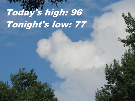
Today, there is a 20 percent chance of showers and thunderstorms before 11 a.m., the weather service said. It will be partly sunny and hot, with a high near 96 and a heat index as high as 107. A light and variable wind will become south southeast 5 to 8 mph in the morning.
Tonight, there is a 20 percent chance of showers and thunderstorms, with a low of 77, according to the weather service. A southeast wind will be about 8 mph.
Thursday, there is a 20 percent chance of showers and thunderstorms after 1 p.m., the weather service said. It will be partly sunny, with a high near 94 and a heat index as high as 102. A southeast wind of 7 to 9 mph will become south southwest in the afternoon.
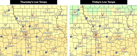
Thursday night, there is a 40 percent chance of showers and thunderstorms, with a low of 74, according to the weather service. A southwest wind of 6 mph will become light and variable in the evening. New rainfall amounts between a tenth and quarter-inch are possible.
Friday, there is a 40 percent chance of showers and thunderstorms, mainly after 1 p.m., the weather service said. The high will be near 87 with a north wind of 5 to 7 mph. Less than a tenth of an inch of rain is possible.
Friday night, there is a 20 percent chance of showers and thunderstorms, with a low of 72, according to the weather service.
Saturday, it will be mostly sunny with a high near 87, the weather service said.
Saturday night, it will be mostly clear, with a low of 68, according to the weather service.
Sunday, it will be sunny, with a high near 92, the weather service said.
Sunday night, it will be mostly clear, with a low of 72, according to the weather service.
Monday, it will be sunny, with a high near 95, the weather service said.
Monday night, it will be partly cloudy, with a low of 70, according to the weather service.
Tuesday, it will be mostly sunny, with a high near 90, the weather service said.
For more weather information, visit www.weather.gov.