After rain last night and this morning, skies should clear by midday and temperatures should reach a high of 89 Wednesday, according to the National Weather Service forecast.
At 9 a.m. Wednesday, a storm was moving to the south of the Kansas City area. There was also a slight chance of more rain before noon.
During last night’s lightning and high winds, the Board of Public Utilities’ outage map said 2,489 customers were without power at 11 p.m. At 9:45 a.m. Wednesday, the BPU’s outage map said 292 customers were without power.
The pattern of evening to early next morning thunderstorm chances will continue for the next few days, the weather service said.
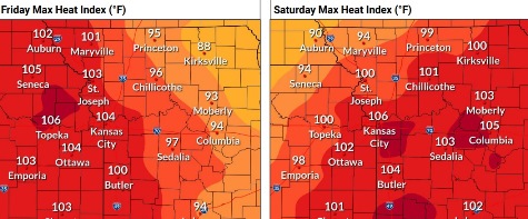
Heat will build back in Friday and Saturday, when the heat index could be around 100 to 105, according to the weather service.
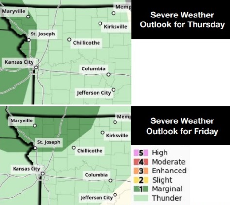
Showers and thunderstorms could form during the evening hours Thursday, continue through the overnight and may linger into the next morning, the weather service said. An isolated strong to severe storm is possible. The primary hazard is damaging winds, according to the weather service.
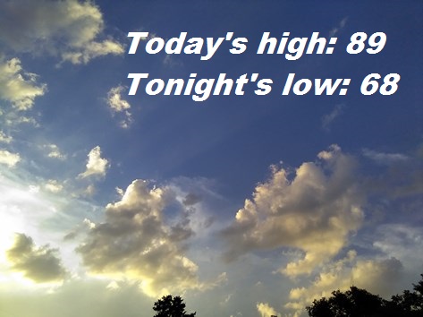
Today, there is a 20 percent chance of showers before 10 a.m., with a high near 89 and a northeast wind around 6 mph, the weather service said.
Tonight, it will be partly cloudy, with a low of 68 and a light northeast wind, according to the weather service.
Thursday, there is a 20 percent chance of showers, with thunderstorms also possible after 4 p.m., the weather service said. The high will be near 89 with a calm wind becoming south southeast 5 to 7 mph in the morning.
Thursday night, there will be a 30 percent chance of thunderstorms before 7 p.m., then a chance of showers and thunderstorms after 1 a.m., according to the weather service. The low will be around 73 with a south southeast wind of 7 mph. Less than a tenth of an inch of rain is possible.
Friday, there is a 20 percent chance of showers and thunderstorms before 1 p.m., with a high near 95, the weather service said. A southeast wind of 6 to 14 mph will gust as high as 24 mph.
Friday night, there is a 20 percent chance of thunderstorms and showers after 1 a.m., with a low of 79, according to the weather service.
Saturday, it will be mostly sunny, with a high near 95, the weather service said.
Saturday night, there is a 30 percent chance of showers after 1 a.m. It will be mostly cloudy, with a low of 70.
Sunday, it will be partly sunny, with a high near 81, the weather service said.
Sunday night, it will be mostly cloudy, with a low of 62, according to the weather service.
Monday, it will be mostly sunny, with a high near 82, the weather service said.
Monday night, it will be partly cloudy, with a low of 62, according to the weather service.
Tuesday, it will be mostly sunny, with a high near 86, the weather service said.