Snow is in the forecast for late Wednesday evening through Thursday morning, according to the National Weather Service.
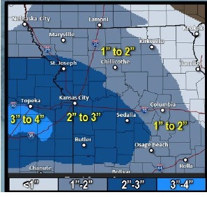
Amounts of snow may range from 1 to 3 inches, with 2 to 3 inches expected across the Kansas City area, the weather service said. Isolated pockets may receive 4 inches of snow.
Most of the snow is expected to fall between midnight and 6 a.m. in a fast-moving storm, according to the weather service.
As the snow winds down, light freezling drizzle may occur during the day Thursday, the weather service said.
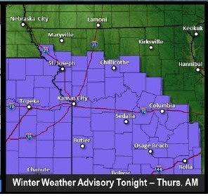
The winter weather advisory for light snow and freezing drizzle will be in effect from 6 p.m. tonight to 9 a.m. Thursday.
Because light snow will likely accumulate on roadways, causing them to be slick, and freezing drizzle will cause a glazing of ice, drivers are advised to be very careful in their early morning commutes on Thursday, the weather service said.
Today’s high will be near 34, while tonight’s low will be around 28.
Thursday’s high is expected to be near 35, and there may be freezing drizzle before noon. Thursday night, the low will be around 28 and there is a chance of drizzle or freezing drizzle.
Friday, it will be cloudy with a high near 37. Friday night, the skies will be mostly cloudy with a low of 28.
Saturday, the forecast is partly sunny, with a high near 39. Saturday night, the low will be around 30.
On Sunday, expect partly sunny skies and a high near 44. Sunday night, mostly cloudy with a low of 35.
Monday’s forecast is partly sunny, a high near 46, and a 30 percent chance of rain. Monday night, a 30 percent chance of rain, with a low around 36.
Tuesday, it will be partly sunny with a high near 43.