Rain and storms are in the forecast for Wednesday and Thursday, according to the National Weather Service.
Several rounds are possible for strong storms starting today and into the weekend, the weather service said.
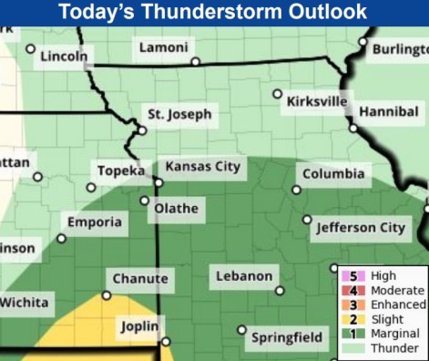
Today, Wyandotte County is at marginal risk for severe storms. Large hail is possible with these storms, according to the weather service. The area at greater risk on Wednesday is south of I-70 and west of I-49.
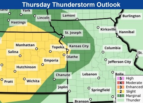
On Thursday, Wyandotte County will be at a slight risk for severe storms, according to the weather service. Strong storms are possible Thursday afternoon into the evening, some capable of producing large hail.
On Saturday, thunderstorms are possible by the evening hours and overnight, the weather service said. There could be isolated instances of straight line winds with stronger storms.
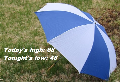
High temperatures this week will be up and down over the next few days. Today’s high will be near 68; Thursday’s will be 74; Friday, 82; Saturday, 76; and Sunday, 62, according to the weather service.
Today, there is a 60 percent chance of showers and possibly a thunderstorm before noon, then a chance of showers and thunderstorms after noon, the weather service said. The high will be near 68 with a south wind of 15 to 17 mph, gusting as high as 32 mph. Less than a tenth of an inch of rain is expected.
Tonight, it will be partly cloudy, with a low of 48 and a west northwest wind of 5 to 9 mph becoming light and variable after midnight, according to the weather service. Winds may gust up to 20 mph.
Thursday, there is a 50 percent chance of showers, with thunderstorms also possible after 1 p.m., the weather service said. The high will be near 74, with a light east wind becoming east southeast 8 to 13 mph in the morning. Winds may gust up to 22 mph. Less than a tenth of an inch of rain is in the forecast.
Thursday night, there is a 60 percent chance of rain and possibly a thunderstorm before 1 a.m., then a chance of showers and thunderstorms after 1 a.m., according to the weather service. The low will be around 63. An east southeast wind of 10 to 14 mph will gust as high as 22 mph. Between a tenth and quarter inch of rain is in the forecast.
Friday, it will be mostly sunny, with a high near 82, the weather service said. A south wind of 13 to 20 mph will gust as high as 32 mph.
Friday night, it will be partly cloudy with a high near 66, and breezy, according to the weather service.
Saturday, there is a 50 percent chance of showers after 1 p.m., the weather service said. The high will be near 76, and it will be breezy.
Saturday night, there is an 80 percent chance of showers and possibly a thunderstorm, according to the weather service. The low will be around 51, and it will be breezy.
Sunday, there is a 40 percent chance of showers, with a high near 62, the weather service said.
Sunday night, it will be partly cloudy, with a low of 42, according to the weather service.
Monday, it will be sunny, with a high near 63, the weather service said.
Monday night, it will be mostly clear, with a low of 42, according to the weather service.
Tuesday, it will be sunny, with a high near 67, the weather service said.