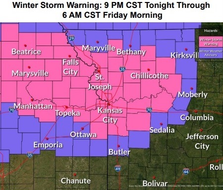
A winter storm warning is in effect for Wyandotte County from 9 p.m. Wednesday, March 9, through 6 a.m. Friday, March 11, according to the National Weather Service.
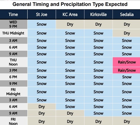
Snow is in tonight’s forecast starting at midnight, but mostly after 3 a.m., the weather service said.
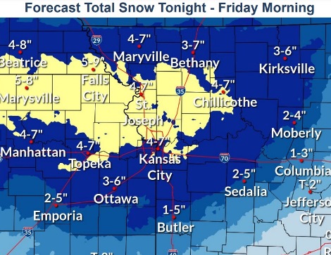
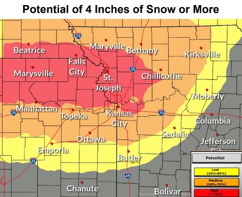
The greatest snowfall amounts are forecast between St. Joseph, Missouri, and Kansas City, and parts of Wyandotte County could receive heavy snowfalls, according to the weather service. About one inch of snow is in the Wednesday night forecast, while two to four inches of snow are in the forecast for parts of Wyandotte County on Thursday.
Travel, especially the Thursday morning commute, can be affected by the snowfall, the weather service said.
Well below normal temperatures are expected Thursday through Saturday, according to the weather service. Thursday night’s low will be 17, while Friday night’s low will be around 4. Temperatures will go from a high of 35 on Saturday to 58 on Sunday.
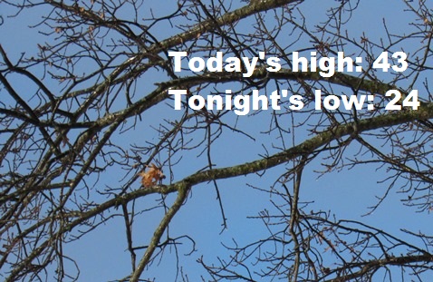
Today, there will be increasing clouds, with a high near 43 and a north wind of 7 to 10 mph, the weather service said.
Tonight, there is a 70 percent chance of snow, mainly after 3 a.m., according to the weather service. The low will be around 24 with a northeast wind of 9 to 13 mph, gusting as high as 22 mph. Around an inch of snow is possible.
Thursday, there is a 90 percent chance of snow, with a high near 27, the weather service said. A northeast wind will be 11 to 14 mph, gusting as high as 23 mph. From 2 to 4 inches of snow are possible.
Thursday night, there is a 40 percent chance of snow, mainly before midnight, according to the weather service. The low will be around 17 with a north wind of 6 to 10 mph, gusting as high as 20 mph.
Friday, it will be partly sunny, with a high near 33, the weather service said. A north northwest wind of 6 to 15 mph will gust as high as 22 mph.
Friday night, it will be mostly clear, with a low of 4, according to the weather service.
Saturday, it will be sunny, with a high near 35, the weather service said.
Saturday night, it will be mostly clear, with a low of 28, according to the weather service.
Sunday, it will be sunny, with a high near 58, the weather service said.
Sunday night, it will be partly cloudy, with a low of 39, according to the weather service.
Monday, it will be mostly sunny, with a high near 56, the weather service said.
Monday night, it will be mostly clear, with a low of 32, according to the weather service.
Tuesday, it will be sunny, with a high near 66, the weather service said.
For weather updates, visit www.weather.gov.