A New Year’s Eve storm is in the forecast from the National Weather Service.
According to the weather service, the storm will begin Friday night and continue through Saturday.
Temperatures will drop below freezing early Saturday morning and remain subfreezing through Monday afternoon, the weather service said. Wind chills Saturday night will range from minus 5 to 20 degrees.
Precipitation on Friday night, New Year’s Eve, will build in from the south, according to the weather service. A little rain before midnight will be followed by a slight chance of snow between midnight and 1 a.m., and then snow mixed with freezing rain after 1 a.m.
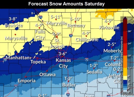
There will be a transition to all snow around noon Saturday, New Year’s Day, the weather service said. Three to five inches of snow is possible, according to the weather service.
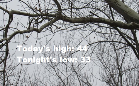
Today, it will be mostly cloudy through mid-morning, then gradually clearing, with a high near 44, the weather service said. A calm wind will become southwest around 6 mph in the afternoon.
Tonight, there will be increasing clouds, with a low of 33 and a calm wind becoming south around 5 mph after midnight, according to the weather service.
Friday, it will be partly sunny, with a high near 55, the weather service said. A south southeast wind of 5 to 9 mph will become west in the afternoon. Winds may gust as high as 20 mph.
Friday night, New Year’s Eve, there is a slight chance of rain before midnight, then a slight chance of snow between midnight and 1 a.m. Snow is likely, possibly mixed with freezing rain, after 1 a.m., according to the weather service. The low will be around 20 with a north northeast wind of 7 to 13 mph, gusting to 21 mph. Little or no ice accumulation is expected. New snow accumulation of less than a half-inch is possible.
Saturday, New Year’s Day, there is a 70 percent chance of snow, mainly before 1 p.m., the weather service said. There will be patchy blowing snow after noon. The high will be near 21 with a north wind of 14 to 18 mph, gusting as high as 30 mph. New snow accumulation of three to five inches is possible.
Saturday night, there is a 40 percent chance of snow before 1 a.m., with a low around 0, according to the weather service.
Sunday, it will be sunny, with a high near 25, the weather service said.
Sunday night, it will be mostly clear, with a low of 16, according to the weather service.
Monday, it will be sunny, with a high near 44, the weather service said.
Monday night, it will be mostly clear, with a low of 29, according to the weather service.
Tuesday, it will be mostly sunny, with a high near 45, the weather service said.
Tuesday night, it will be partly cloudy, with a low of 28, according to the weather service.
Wednesday, it will be mostly sunny, with a high near 42, the weather service said.