Waste Management will not collect residential trash and recycling on Wednesday, Feb. 2, according to a news release from the Unified Government.
Residential trash and recycling collection will be delayed by one day this week: • If your normal day is Wednesday, place your items at the curb or street edge on Thursday, Feb. 3. • If your normal day is Thursday, place your items at the curb or street edge on Friday, Feb. 4. • If your normal day is Friday, place your items at the curb or street edge on Saturday, Feb. 5.
Due to low temperatures and the heavy snowfall anticipated on Wednesday, Feb. 2, residents should prepare for the possibility of additional delays, according to the announcement.
More information will follow if residential trash and recycling services are further delayed by hazardous weather.
“This is shaping up to be a very challenging storm,” said Dave Reno, Public Works’ community engagement officer, “Although we do not anticipate further delays this week, residents should prepare for the possibility of their trash and recycling collection being pushed back another day later this week. Public Works extends its thanks to everyone for their patience during this storm – keep your eyes on the Unified Government’s website and social media for updates as we move forward.”
To learn more about Solid Waste Management, view frequently asked questions, and helpful tips, visit wycokck.org/Waste.
To report service issues, dial 3-1-1 or visit mywyco.wycokck.org.
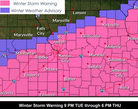
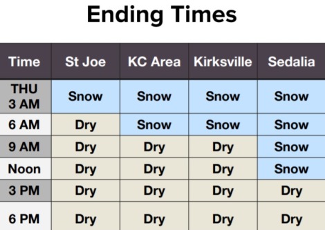
Wyandotte County is under a winter storm warning from Tuesday night to Thursday evening. (National Weather Service graphic)Possible snow totals for Tuesday night through Thursday. Wyandotte County is near a line where snow totals change. (National Weather Service graphic)The storm’s projected start time in the Kansas City area is 3 p.m. Tuesday for rain, and 9 p.m. for snow. (National Weather Service graphic)The storm’s end will be around 9 a.m. Thursday in the Kansas City area. (National Weather Service graphic)Residents are advised to drive carefully if they go out in the ice and snow. (National Weather Service graphic)Temperatures will be very cold on Friday morning, around zero. (National Weather Service graphic)Wind chills on Friday morning will drop below zero. (National Weather Service graphic)
Wyandotte County is under a winter storm warning, in effect from 9 p.m. Tuesday to 6 p.m. Thursday, according to the National Weather Service.
Heavy snow is possible, plus freezing rain, according to the weather service. Travel may be hazardous, and power outages may be possible, the weather service said.
There is a 100 percent chance of precipitation tonight, with rain possible before 8 p.m., followed by snow, the weather service said. From 1 to 3 inches of snow is possible tonight.
Wednesday, an additional 3 to 5 inches of snow is possible, with a 100 percent chance of precipitation, according to the weather service. The weather service is encouraging residents to stay home.
It may continue snowing Wednesday night, with another inch of snow possible before midnight, the weather service said.
A cold front is moving through the area today and tonight, bring temperatures that are well below normal, according to the weather service. The temperature will drop to a low of minus 1 on Thursday night.
According to the weather service, there is still some uncertainty as to the amount of snow the Kansas City area will receive.
Today, there is a 20 percent chance of rain after 3 p.m. The high will be near 49 with a north wind of 8 to 14 mph, gusting as high as 21 mph.
Tonight, there is a 100 percent chance of rain before 8 p.m., then snow. The low will be about 16, with a north northeast wind of 14 to 16 mph. Gusts will be as high as 23 mph. From 1 to 3 inches of snow is possible tonight.
Wednesday, there is a 100 percent chance of snow, with a high near 21, the weather service said. A north northeast wind of 14 to 16 mph will gust as high as 25 mph. From 3 to 5 inches of snow is possible.
Wednesday night, there is a 60 percent chance of snow, mainly before midnight, according to the weather service. The low will be around 8, with wind chill values between minus 5 and 4. A north northeast wind of 15 mph will gust as high as 22 mph. Less than one inch of snow is possible.
Thursday, it will be partly sunny, with a high near 18 and a north wind of 9 to 15 mph, gusting up to 24 mph, the weather service said.
Thursday night, it will be partly cloudy, with a low of minus 1, according to the weather service.
Friday, it will be sunny, with a high near 27, the weather service said.
Friday night, it will be mostly clear, with a low of 8, according to the weather service.
Saturday, it will be sunny, with a high near 34, the weather service said.
Saturday night, it will be mostly clear, with a low of 19, according to the weather service.
Sunday, it will be mostly sunny, with a high of 35, the weather service said.
Sunday night, it will be mostly clear, with a low of 14, according to the weather service.
Monday, it will be sunny, with a high near 39, the weather service said.
For more weather information, visit www.weather.gov.