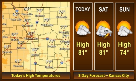
Sunny skies are in today’s forecast, with the next chance for rain on Saturday night and Sunday.
More storms will be possible on Monday night into Tuesday, according to the National Weather Service forecast.
Today, there will be mostly sunny skies with a high near 80, the weather service said. An east southeast wind of 6 to 11 mph will become south 12 to 17 mph in the afternoon, with winds gusting as high as 31 mph.
Tonight, it will be mostly clear, with a low of 59, and a south southwest wind of 5 to 9 mph, according to the weather service.
Saturday, it will be mostly sunny, with a high near 80 and a light and variable wind becoming east northeast 5 to 10 mph in the morning, the weather service said.
Saturday night, there is a 50 percent chance of showers and thunderstorms, with a low of 57, according to the weather service, and a northeast wind of 6 mph. Between a tenth and quarter-inch of rain is possible.
Sunday, there is a 30 percent chance of showers before 1 p.m., with a high near 73, the weather service said, and an east northeast wind of 3 to 6 mph. Less than a tenth of an inch of rain is in the forecast.
Sunday night, it will be mostly clear, with a low of 56, according to the weather service.
Monday, it will be mostly cloudy, with a high near74, the weather service said.
Monday night, there is a 50 percent chance of showers and thunderstorms, with a low of 56, according to the weather service.
Tuesday, it will be partly sunny, with a high near 72, the weather service said.
Tuesday night, it will be mostly clear, with a low of 50, according to the weather service.
Wednesday, it will be partly sunny, with a high near 67, the weather service said.
Wednesday night, it will be partly cloudy, with a low of 49, according to the weather service.
Thursday, it will be partly sunny, with a high near 68, the weather service said.