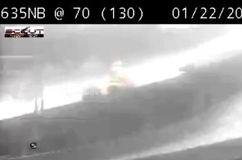
Accident reported near I-635 and I-70
Serving Kansas City (Wyandotte County) Kansas for over 50 years!
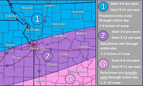
With light snow on Wednesday morning, Wyandotte County will continue under a winter weather advisory until 6 p.m. Wednesday, according to the National Weather Service.
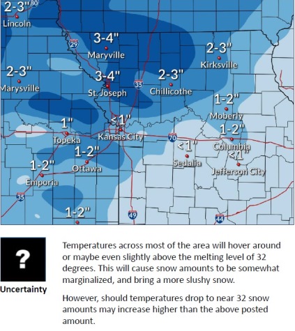
Temperatures were at 34 degrees at 9 a.m. Wednesday, signaling a change to light rain. A snow and rain mixture is possible today, with a slushy snowfall in some areas, the weather service said. If temperatures drop, snow amounts could increase.
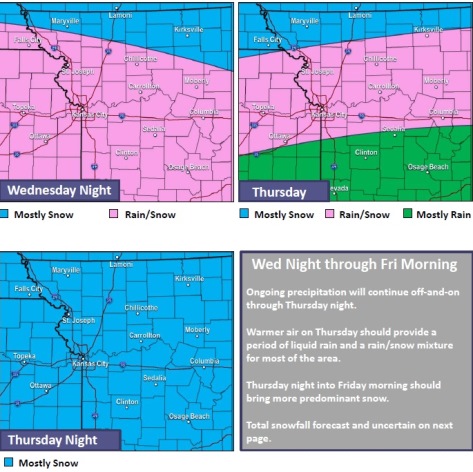
Off and on precipitation will continue through Thursday into Friday morning, the weather service said. There will be a transition to predominantly snow by Friday morning, with another couple inches of accumulation possible Friday.
Motorists are advised to slow down and use caution, as roads may have slick spots, according to the weather service.
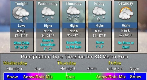
Today, there is a 100 percent chance of rain and snow before 11 a.m., then snow between 11 a.m. and noon, then rain and snow after noon, the weather service said. The high will be near 36 with a south wind of 11 to 14 mph, gusting as high as 25 mph. From 1 to 2 inches of new snow are possible.
Tonight, there is a 70 percent chance of rain and snow, mainly before midnight, according to the weather service. The low will be around 34 with a south southwest wind of 6 to 10 mph, gusting as high as 18 mph. Less than a half-inch of new snow is possible.
Thursday, there is an 80 percent chance of rain and snow before 3 p.m., then rain between 3 p.m. and 4 p.m., then rain, possibly mixed with snow, after 4 p.m., the weather service said. The high will be near 37 with a light and variable wind becoming northwest 5 to 7 mph in the afternoon. Less than a half-inch of new snow is possible.
Thursday night, there is a 60 percent chance of rain and snow, becoming all snow after 9 p.m., according to the weather service. The low will be around 29 with a northwest wind of 5 to 7 mph, gusting as high as 18 mph. Less than one inch of new snow is possible.
Friday, there is a 20 percent chance of snow before noon, with a high near 35, the weather service said. A northwest wind of 8 mph will gust as high as 20 mph.
Friday night, it will be cloudy, with a low of 27, according to the weather service.
Saturday, it will be partly sunny, with a high near 38, the weather service said.
Saturday night, it will be partly cloudy, with a low of 24, according to the weather service.
Sunday, it will be mostly sunny, with a high near 44, the weather service said.
Sunday night, it will be partly cloudy, with a low of 32, according to the weather service.
Monday, it will be mostly sunny, with a high near 51, the weather service said.
Monday night, it will be mostly cloudy, with a low of 38, according to the weather service.
Tuesday, there is a 30 percent chance of rain, with a high near 48, the weather service said.
For more weather information, visit www.weather.gov.
Snow and freezing rain are in the forecast for Wednesday morning, according to the National Weather Service forecast.
Wyandotte County and the surrounding areas are under a winter weather advisory from midnight through noon Wednesday, according to the weather service. Snow is possible from midnight through noon. Freezing rain is possible around 5 a.m. or 5:30 a.m.
Motorists should be prepared for slippery road conditions, and should slow down and use caution, the weather service said.
Snow is likely before 5 a.m., then more snow, possibly mixed with freezing rain, is possible, according to the weather service. Tonight’s low will be around 30, with a half-inch of snow possible.
Wednesday, there could be snow before 10 a.m., then rain and snow between 10 a.m. and noon, the weather service said. Rain will follow after noon. The high will be near 36, and new snow accumulation of around an inch is possible.
Wednesday night, look for more snow in the forecast before 7 p.m., then rain, possibly mixed with snow, according to the weather service. The low will be around 34. Less than an inch of snow is expected.
Thursday, there will be a chance of rain and snow before 2 p.m., followed by rain, the weather service said. The high will be near 38.
Thursday night’s forecast also contains a chance of rain and snow before 10 p.m., according to the weather service.
Friday, there is a slight chance of snow before 2 p.m., then a chance of rain between 2 p.m. and 5 p.m., followed by a slight chance of snow after 5 p.m., the weather service said. The high will be near 36.
No precipitation is in the Saturday and Sunday forecast, with highs in the 30s and 40s.
For more weather information, see www.weather.gov.