Thunderstorms, flooding possible today

Wyandotte County is in an area of enhanced risk for severe storms on Tuesday afternoon and evening. (National Weather Service graphic)
Wyandotte County has a severe hail risk of 30 percent on Tuesday, according to the National Weather Service. (National Weather Service graphic)
There is a threat of high winds on Tuesday. Parts of Wyandotte County may have a 30 percent chance of high winds. (National Weather Service graphic)
Wyandotte County has a 5 percent probability of a few tornadoes on Tuesday. (National Weather Service graphic)
Projected timing of Tuesday’s storms. (National Weather Service graphic)

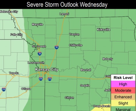
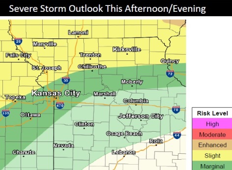
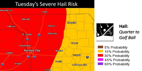
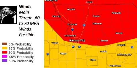
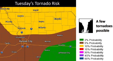
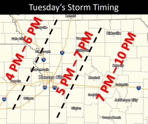
Widespread severe thunderstorms are possible across the area beginning late this afternoon into the evening hours, according to the National Weather Service.

The greatest hazards will be damaging winds, large hail, heavy rain, flash flooding and a few possible tornadoes, the weather service said.

The storm could arrive in Wyandotte County late this afternoon, according to the weather service.

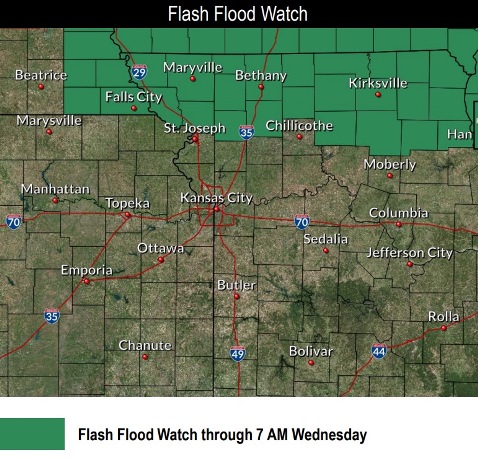
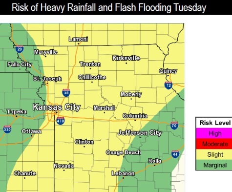
Continued rounds of rain will exacerbate flooding on area rivers, according to the weather service.

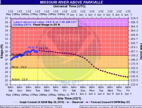
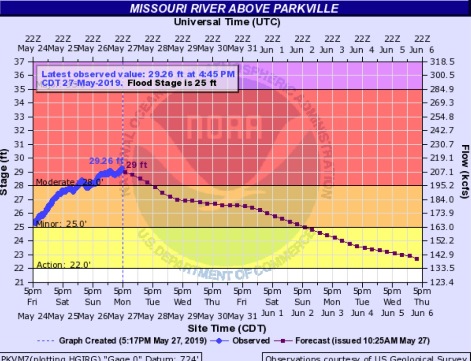
The Missouri River at Parkville, where the gauge is located on I-435 between Wyandotte and Platte counties, is currently at moderate flood stage, according to hydrology charts. The river could fall below flood stage by Monday evening, the weather service said.

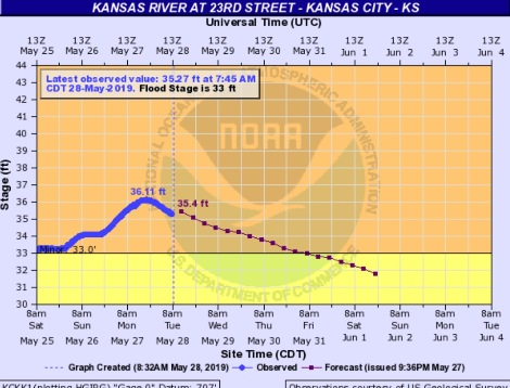
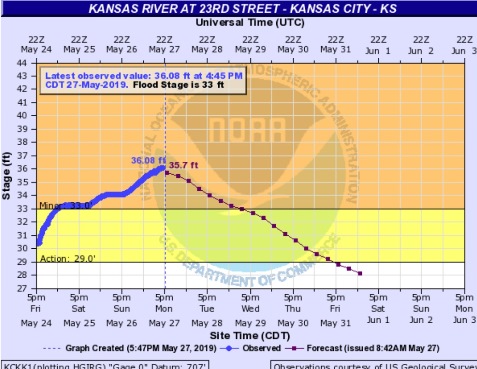
The Kansas River at 23rd Street, where the gauge is at Kansas Avenue at the state line, is currently in minor flood stage. The river could fall below flood stage on Friday morning, according to the weather service.

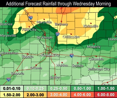
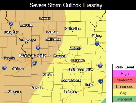
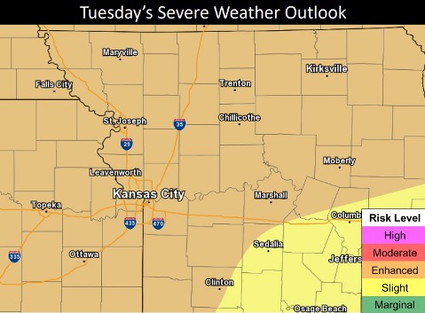
There is rain in the forecast for most of the days of the coming week.

Today, there is a 50 percent chance of showers and thunderstorms, mainly after 3 p.m., the weather service said. The high will be near 81 with a south wind of 7 to 15 mph, gusting to 30 mph. Less than a tenth of an inch of rain is expected.

Tonight, there is a 70 percent chance of showers and thunderstorms, mainly before 1 a.m., according to the weather service. The low will be around 67 with a southwest wind of 8 to 15 mph, gusting as high as 30 mph. Between a tenth and quarter-inch of rain is possible.

Wednesday, it will be partly sunny, with a high near 79 and a west southwest wind of 7 to 9 mph, the weather service said.

Wednesday night, there is a 30 percent chance of showers and thunderstorms, mainly before 1 a.m., according to the weather service. The low will be around 57 with a west wind of 5 to 7 mph. Less than a tenth of an inch of rain is expected.

Thursday, there is a 20 percent chance of showers and thunderstorms after 1 p.m., with a high near 74, the weather service said. A west wind of 7 to 9 mph will gust as high as 18 mph.

Thursday night, it will be partly cloudy, with a low of 57, according to the weather service.

Friday, it will be mostly sunny, with a high near 79, the weather service said.

Friday night, it will be partly cloudy, with a low of 60, according to the weather service.

Saturday, there is a 30 percent chance of showers and thunderstorms after 1 p.m., with a high near 81, the weather service said.

Saturday night, there is a 30 percent chance of showers and thunderstorms before 1 a.m., with a low of 62, according to the weather service.

Sunday, it will be mostly sunny, with a high near 81, the weather service said.

Sunday night, there is a 30 percent chance of showers and thunderstorms, with a low of 63, according to the weather service.

Monday, there is a 30 percent chance of showers and thunderstorms, with a high near 80, the weather service said.

For more weather information, visit www.weather.gov.

A flash flood watch is in effect north of the Wyandotte County area. (National Weather Service graphic)
Additional rainfall is possible through the area through Wednesday morning. (National Weather Service graphic)
Wyandotte County is at marginal risk for severe storms on Wednesday. (National Weather Service graphic)
The Missouri River at Parkville, which covers an area including Wyandotte County, is currently in moderate flood stage. (National Weather Service – USGS graphic)
The Kansas River at 23rd Street, where the gauge is at Kansas Avenue and the state line, is currently in minor flood stage. (National Weather Service – USGS graphic)

River flooding continues

A view of the Kansas River on I-635, near I-70, in Wyandotte County on Monday, May 27. The Kansas River currently is in minor flood stage at some locations.
A view of the Missouri River flooding at I-435 in Wyandotte County. The Missouri River is in moderate flood stage at this location. (KC Scout photo)

The Missouri and Kansas rivers are currently flooding in Wyandotte County.

Continued rain is making the flooding worse along the Missouri River and its tributaries. In addition, water is being released from reservoirs upstream. The Corps of Engineers began releasing water from Perry Lake on Sunday, May 26, as rains caused Perry to rise above pool elevation and into surcharge operations.

The Missouri River at Parkville, Missouri, where the gauge is on I-435 between Wyandotte County and Platte County, is in moderate flood stage currently, according to the weather service. This gauge covers the Wyandotte County area. The river was at 29.26 feet at 4:45 p.m. Monday, where flood stage is 25 feet. The river is expected to fall below flood stage on Sunday evening.

The Kansas River at 23rd Street, where the gauge is at Kansas Avenue and the state line, is in minor flood stage, according to the weather service. At 4:45 p.m. Monday, the Kansas River was at 36.08 feet, where flood stage is 33 feet. The river is expected to fall below flood stage early Wednesday afternoon.

On Tuesday, there is a 70 percent chance of showers and thunderstorms after 4 p.m., with a tenth to a quarter-inch of rain expected.

Tuesday night, there is a 60 percent chance of rain and thunderstorms, with between a quarter and half-inch of rain possible.

Wednesday night, there is a 30 percent chance of rain.

Residents who encounter flooded roadways are encouraged to turn around and take another route.

For more information about the weather, visit www.weather.gov.

The Missouri River at Parkville, an area that includes Wyandotte County, is currently in moderate flood stage. (National Weather Service – USGS graphic)
The Kaw River at 23rd Street, where the gauge is at Kansas Avenue and the state line, is currently in minor flood stage. (National Weather Service – USGS graphic)

More rain possible through Tuesday

Wyandotte County is in a marginal area for severe storms on Monday afternoon and evening. (National Weather Service graphic)
Wyandotte County is in an enhanced risk area for severe storms on Tuesday. (National Weather Service graphic)
Wyandotte County is in an area of slight risk for heavy rainfall and flash flooding Tuesday. (National Weather Service graphic)

Thunderstorms and rain are possible in today’s Memorial Day forecast, according to the National Weather Service.

Wyandotte County experienced some rain earlier this morning, and there is a chance of more rain and storms before 2 p.m., then a slight chance of showers from 2 to 3 p.m., the weather service said.

The high will be near 84 today with a south southwest wind of 10 to 17 mph, gusting as high as 32 mph, according to the weather service. Less than a tenth of an inch of rain is forecast.

These afternoon storms will be most severe along and north of Highway 36, in the St. Joseph, Missouri, area, according to the weather service. This storm could have heavy rain, flash flooding, large hail and an isolated tornado.

Tonight, it will be mostly cloudy, with a low of 70 and a south southwest wind of 10 to 13, gusting as high as 24 mph, according to the weather service.

More widespread severe weather is possible on Tuesday with damaging winds, large hail and a few tornadoes possible, the weather service said. In addition to the severe threat, these storms will be capable of heavy rainfall, which will lead to flash flooding and additional or aggravated river flooding.

Tuesday’s high will be near 80 with a 50 percent chance of precipitation and storms. A south wind of 10 to 15 mph will gust as high as 26 mph. New rainfall will be from a quarter to a half-inch.

Tuesday night, there will be a 70 percent chance of showers and thunderstorms, mainly before 1 a.m., according to the weather service. Cloudy skies will change to partly cloudy, with a low of 64. A south wind of 8 to 13 mph will gust as high as 21 mph. New rainfall between a quarter and half-inch is possible.

Wednesday, it will be mostly sunny, with a high near 71, the weather service said. A southwest wind of 8 to 11 mph will gust as high as 23 mph.

Wednesday night, there is a 30 percent chance of showers and thunderstorms, mainly before 1 a.m., according to the weather service. The low will be around 58, and new rainfall will be less than a tenth of an inch.

For more weather information, visit www.weather.gov.