An injury-accident was reported after a deer ran into a motorcycle at 7:03 a.m. Thursday, June 28, on the eastbound I-70 ramp to I-635 southbound.
A Harley Davidson motorcycle was traveling eastbound on I-70, exiting on I-635 southbound, according to the Kansas Highway Patrol trooper’s report.
At the beginning of the exit, a deer came across all lanes of traffic and struck the rear tire of the motorcycle, the trooper’s report stated.
A 53-year-old Topeka, Kansas, man driving the motorcycle was injured and taken to the hospital, according to the trooper’s report. The driver was wearing a helmet.
A free citizenship preparation program will be offered Wednesdays and Thursdays, July 25 to Sept. 27, at the Main Kansas City, Kansas, Public Library, 625 Minnesota Ave.
The program will be from 6 p.m. to 8 p.m.
The classes, offered by Catholic Charities and the library, will include course work on the English language, American history and civics knowledge that is needed to pass the naturalization interview and exam. Class size is limited to 25.
Adults 18 and older may participate if they have had their green card for at least five years.
To enroll, call Elena at 913-295-8250, Ext. 1122, or email [email protected].
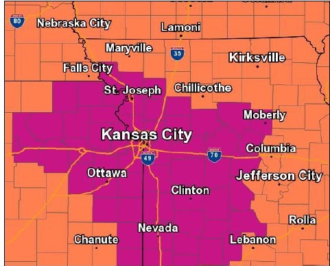
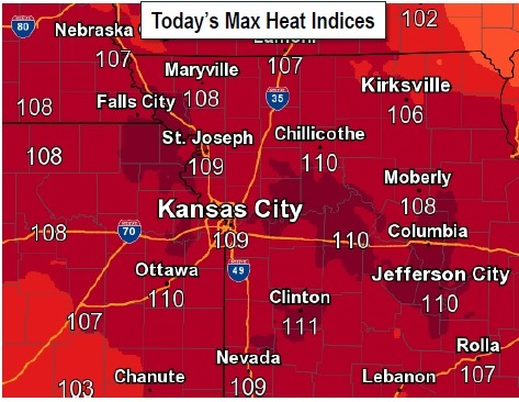
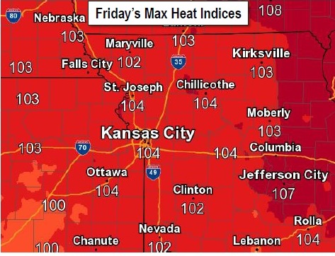
An excessive heat warning will be in effect for Wyandotte County and the surrounding area. (National Weather Service graphic) Today’s maximum heat index is over 100 in Wyandotte County. (National Weather Service graphic) Friday’s maximum heat index also is over 100. (National Weather Service graphic)
An excessive heat warning will be in effect from noon today until 7 p.m. June 30, according to the National Weather Service. Temperatures may reach 101 this afternoon, with a heat index of 110.
High temperatures will be in the low to mid 90s with heat index values between 100 and 105 degrees, according to the weather service.
The heat index will exceed 105 degrees and reach 110 degrees Thursday and Friday afternoons with overnight heat index values only dropping into the upper 70s both Thursday and Friday nights, the weather service said.
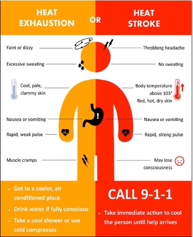
Heat illnesses are possible for those spending prolonged time outdoors or those more susceptible to heat illnesses, such as children and the elderly, according to the weather service.
Residents should take extra precautions if they work or spend time outside. When possible, reschedule strenuous activities to early morning or evening. Know the signs and symptoms of heat exhaustion and heat stroke. Wear lightweight and loose-fitting clothing when possible and drink plenty of water.
The heat may be dangerous. Drink plenty of water, stay in an air-conditioned room, stay out of the sun and check on neighbors, according to the weather service.
The hot weather is expected to continue Friday and Saturday, although today will be the hottest day, according to the weather service.
For a list of cooling centers, see https://www.facebook.com/notes/kansas-city-kansas-unified-government/cooling-centers-spray-parks-and-pools/2505697519455873/.
Also, the weather service said moderate river flooding is expected along the Missouri River from Nebraska City down through St. Joseph, Missouri. Atchison, Kansas, could see minor flooding.
This could cause flooding in low-lying rural areas along the river not protected by levees, according to the weather service. Minor flooding is expected further downstream with little impact, the weather service stated.
In Wyandotte County, there are no rivers currently in flood stage.
Today, it will be sunny and hot, with a high near 101, the weather service said, and a heat index as high as 110. A south southwest wind of 8 to 13 mph is in the forecast.
Tonight, it will be mostly clear with a low of 78 and a south wind of 9 to 13 mph, according to the weather service.
Friday, it will be sunny and hot, with a high near 98, and heat index values as high as 103, the weather service said. A south southwest wind of 10 to 15 mph will gust as high as 25 mph.
Friday night, it will be clear with a low of 77, and a south wind of 10 to 14 mph, gusting as high as 23 mph, according to the weather service.
Saturday, it will be sunny with a high near 95 and a south wind of 10 to 14 mph, gusting as high as 23 mph, the weather service said.
Saturday night, there is a 60 percent chance of showers and thunderstorms, mainly after 1 a.m., according to the weather service. The low will be around 72.
Sunday, it will be partly sunny with a high of 88, the weather service said.
Sunday night, there is a 30 percent chance of showers and thunderstorms after 1 a.m., with a low of 71, according to the weather service.
Monday, it will be mostly sunny with a high of 91, the weather service said.
Monday night, the low will be around 75, according to the weather service.
Tuesday, the high will be near 95, the weather service said.
Tuesday night, the low will be around 75, according to the weather service.
On Wednesday, Independence Day, the forecast is sunny with a high of 94, the weather service said.
Get to a cooler place and drink water if there are signs of heat exhaustion. For heat stroke, call 911. (National Weather Service graphic)