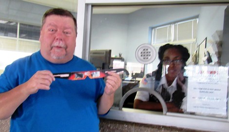
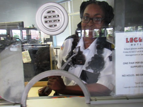
David Howard of Wyandotte County picked up a pair of solar eclipse glasses this morning at The Legends Outlets’ security window at the parking garage, at the Kansas City, Kansas, shopping center. There was a lot of traffic this morning at The Legends, attributed to a solar eclipse glasses giveaway. This office was giving out one pair of glasses per person. The glasses were from the Kansas City, Kansas, Convention and Visitors Bureau. (Staff photo)The Legends Outlets security office at the parking garage was one of several places distributing solar eclipse glasses today. The glasses were provided by the Kansas City, Kansas, Convention and Visitors Bureau, and are available at area hotels, museums in Wyandotte County, The Legends Outlets, and at attractions such as T-Bones games and the Schlitterbahn waterpark, while supplies last. (Staff photo)The solar eclipse glasses provided by the Kansas City, Kansas, Convention and Visitors Bureau have the phrases, “Kansas City, KS Solar Eclipse, August 21, 2017” and “VisitKansasCityKs.com” printed on the earpieces. They are cardboard glasses with special lenses to protect the eyes. Experts warn to never look at the sun without eye protection.
A solar eclipse will be visible from Kansas City, Kansas, on Aug. 21, and several special events are planned for it. Special eclipse glasses, ISO 12312-2 compliant, are needed for viewing, according to NASA. (Artist’s rendition, copyright 2017, not actual solar viewing glasses)
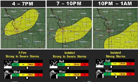
Strong to severe storms are in today’s forecast, according to the National Weather Service. (National Weather Service graphic)
A cold front will be moving into the area this afternoon that will help develop some strong to severe storms along it in the afternoon, according to the National Weather Service.
The initial threat will be large hail and damaging winds which will transition to mostly damaging winds as it forms into a line near sunset, the weather service said.
Benign weather returns for this weekend with temperatures creeping back up into the upper 80s to some lower 90s by Sunday, according to the weather service. Heat index values will be in the upper 90s by Sunday.
Today, there is a 30 percent chance of showers and thunderstorms, mainly after 4 p.m., the weather service said. The high will be near 88 with a calm wind becoming southwest 5 to 9 mph in the morning.
Tonight, there is a 40 percent chance of showers and thunderstorms before 1 a.m., according to the weather service. The low will be around 65, with a south southwest wind of 5 to 7 mph becoming calm in the evening. Between a tenth and quarter inch of rain is possible.
Saturday, it will be sunny with a high near 90, the weather service said. A calm wind will become south southwest around 5 mph in the afternoon.
Saturday night, there is a 20 percent chance of showers and thunderstorms after 1 a.m., according to the weather service. The low will be 69 with a light southeast wind.
Sunday, expect a 20 percent chance of showers and thunderstorms after 1 p.m., the weather service said. The high will be near 90, with a south wind of 3 to 7 mph.
Sunday night, there is a 30 percent chance of showers and storms, mainly after 1 a.m., according to the weather service. The low will be 73.
Monday, the day of the solar eclipse, there is a 30 percent chance of showers with a high near 90, the weather service said. It will be partly sunny.
Monday night, there is a 40 percent chance of showers and thunderstorms after 1 a.m., according to the weather service. The low will be around 74.
For Monday, Aug. 21, the weather service said a trend in the model data has been a line of thunderstorms developing along the Iowa-Missouri border into Iowa Sunday night into Monday morning.
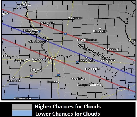
An upper level jet stream is expected to move into Kansas overnight creating the possibility of upper-level clouds that may move over the region during the time of the eclipse, according to the weather service. These are very thick clouds with little breaks, usually, but the placement of the band of clouds varies in some of the models, so there is still hope that the clouds will go north and west that day, according to the weather service.
It is still considered too early to know the forecast for the day of the eclipse, but currently, it appears that it might be cloudy, and the forecast may change.
The current forecast for Monday, Aug. 21, the day of the solar eclipse, is cloudy. However, the forecast may change. (National Weather Service graphic)
Kansas City, Kansas, police are investigating a homicide in the 2000 block of Tremont, according to a police spokesman.
Police were called to a shooting about 9:30 p.m. Thursday, Aug. 17, and found a juvenile male who was deceased from an apparent gunshot wound to his chest, the spokesman stated.
The identity of the victim is being withheld until there is positive identification and family notification, police said.
The Kansas City, Kansas, Police Department’s Criminal Investigations Division is investigating. Anyone with information is asked to call the TIPS hotline at 816-474-TIPS.