Cleanup begins after Monday night storm

A downed tree blocked 81st Street at Roswell Avenue this morning, after a severe thunderstorm on Monday night. (Staff photo by Mary Rupert)

Limbs were down at 81st and Georgia this morning after a storm hit Monday night. (Staff photo by Mary Rupert)

A tree was down in front of a home at 83rd and Georgia in Kansas City, Kansas, this morning, after a storm hit Monday night. (Staff photo by Mary Rupert)

by Mary Rupert

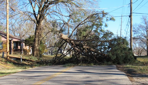
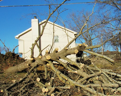
Some Wyandotte County residents are cleaning up this morning after a storm on Monday night resulted in tree limbs down across the area.

The Bethel neighborhood was particularly hard hit by trees down, with one tree across the road closing 81st Street near Roswell Avenue in Kansas City, Kansas.

Matt May, Wyandotte County emergency management director, said early reports are that some trees and power lines were down in Wyandotte County. Power was out to about 5,000 to 6,000 people last night, but that was quickly narrowed to 2,000 by 11 p.m. Monday, he added, and power was still out this morning at an estimated 1,500 homes.

“We fared a little better than our brothers to north, and especially Oak Grove,” May said. “We got very lucky last night.”

Most of the damage in the metropolitan area was on either side of Wyandotte County, he said. It is believed that a tornado hit Oak Grove, Missouri, leaving significant damage. Also, Johnson County Executive Airport was damaged by the storm, with more than 10 airplanes affected, May said. The Kansas City, Kansas, Fire Department crews assisted the airport last night in handling fuel spills from the damage, he said.

He said there were significant straight line winds here, although he doesn’t think that there was a tornado in Wyandotte County. Winds were at least 40 to 50 mph, with the storm moving in excess of 65 mph, he added.

The emergency management office is assessing damage this morning, he said. So far, it appears it’s mostly tree, wind and hail damage, and some window damage in Wyandotte County, he said. There was also significant lightning in the area.

A statewide tornado drill test is still planned for 10 a.m. today, he said. He is asking people to go through their normal tornado routine, finding shelter in the lowest area of a structure, during the drill today whether they are at home, in school or at work.

Extreme fire danger today, weather service says

There is a red flag warning today in Wyandotte County and the surrounding area, indicating extreme fire danger. (National Weather Service graphic)
After high winds, rain and lightning that hit Wyandotte County and the surrounding area last night, today’s weather will be comparatively calmer.

But there will be an extreme fire danger today, and Wyandotte County is under a red flag warning from 11 a.m. to 6 p.m., the National Weather Service said. Residents are warned not to burn outdoors.

Although it rained last night, there will be high winds today plus relative humidity values of 15 to 25 percent, according to the weather service. The conditions will allow any wet fuels to dry out and cause extreme fire danger, the weather service said.

Tornados and high-wind destruction last night damaged the Johnson County (Kansas) Executive Airport, Leawood, Kansas, and Oak Grove, Missouri, homes and buildings, plus many other places in a three-state area.

Many power outages were reported Monday night in Kansas City, Kansas, according to the Board of Public Utilities’ outage map. Possibly thousands of people were without power at one time.

Also, today there is a scheduled test, a National Weather Service tornado preparedness drill, scheduled between 9:30 a.m. and 10:30 a.m., according to the Unified Government. Sirens may sound at that time. If there is threatening weather at that time, the test will be canceled.

Today, the high will be near 59 with sunny skies, the weather service said. A west wind of 7 to 12 mph could increase to 17 to 22 mph in the afternoon, gusting to as high as 40 mph.

Tonight, it will be clear with a low of 34, the weather service said. A southwest wind of 6 to 15 mph will gust as high as 23 mph.

Wednesday, expect sunny skies with a high of 67, according to the weather service. A southwest wind of 6 to 16 mph will gust as high as 79 mph.

Wednesday night, it will be mostly clear with a low of 42, the weather service said. There will be a south southwest wind of 8 mph.

Thursday, skies will be mostly sunny with a high near 69, according to the weather service. A south southwest wind of 7 mph will become north in the afternoon.

Thursday night, it will be mostly clear with a low of 36, the weather service said.

Friday, the forecast will be mostly sunny with a high near 52, according to the weather service.

Friday night, there is a 60 percent chance of rain after midnight, mixing with snow after 3 a.m., the weather service said. The low will be around 34.

Saturday, expect a 70 percent chance of rain and snow, then becoming all rain after 9 a.m., the weather service said. The high will be near 44.

Saturday night, it will be partly cloudy with a low of 26, according to the weather service.

Flash flood warning issued for Wyandotte County

A flash flood warning has been issued for Wyandotte County, according to the National Weather Service, until 11:30 p.m.

At 8:25 p.m., local law enforcement officials reported heavy rain across the warned area. Flash flooding is already occurring.

Kansas City, Kansas, Bonner Springs and Edwardsville are in the flash flooding area, the weather service said. Neighboring counties also may be in the flooding area.

The weather service advised to turn around when encountering flooded roadways and do not attempt to drive through them. Be especially cautious at night, the weather service said.