Isolated storms possible today; snow possible Saturday

National Weather Service graphic

National Weather Service graphic

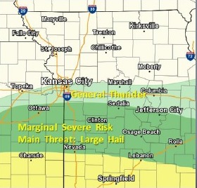
Isolated severe storms will be possible this afternoon, mostly along a line south of the Kansas City area, from Gardner, Kansas, to Sedalia, Missouri, according to the National Weather Service.

The main threat from the storms will be a potential for large hail, the weather service said.

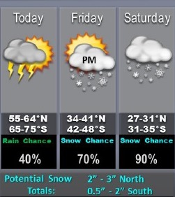
Accumulating snow is likely Friday night after midnight into Saturday, according to the weather service.

Accumulations of 2 to 3 inches will be possible along and north of the Highway 36 corridor, near St. Joseph, Missouri, with accumulations of one-half to 2 inches further south, the weather service said.

Today, expect mostly sunny skies and a high near 71, with a light and variable wind becoming north northwest 8 to 13 mph in the morning, the weather service said.

Tonight, it will be mostly clear, with a low of 31, according to the weather service. A north northeast wind of 10 to 16 mph may gust as high as 24 mph.

Friday, it will be mostly sunny with a high near 44, the weather service said, and a northeast wind of 9 to 11 mph.

Friday night, there will be a 50 percent chance of rain and snow between midnight and 1 a.m., then a chance of snow after 1 a.m., according to the weather service. It will be mostly cloudy, with a low of 27, and an east wind of 9 to 11 mph.

Saturday, there will be an 80 percent chance of precipitation, with snow before 3 p.m., then a chance of rain and snow between 3 p.m. and 5 p.m., followed by a chance of rain after 5 p.m., the weather service said. The high will be near 34, with an east wind of 8 to 13 mph. From 1 to 2 inches of snow is possible, according to the forecast.

Saturday night, it will be partly cloudy, with a low of 18, according to the weather service.

Sunday, it will be partly sunny with a high near 40, the weather service said.

Sunday night, there is a 60 percent chance of rain before 8 p.m., then a chance of rain and snow between 8 p.m. and 10 p.m., followed by snow after 10 p.m., according to the weather service. It will be mostly cloudy with a low of 31.

Monday, the high will be near 60 with mostly cloudy skies.

Monday night, expect a low of 19 with mostly cloudy skies, the weather service said.

Tuesday, it will be partly sunny with a high of 41, according to the weather service. Tuesday night, the low will be around 28.

For more weather information, visit www.weather.gov.

Spring musical set this weekend at Bishop Ward

Bishop Ward High School students are presenting a spring musical this weekend. (Photo from Bishop Ward)

The Bishop Ward Drama Club is taking a journey into high school in this weekend’s musical production, “Homework Eats Dog.”

The public may attend the musical production, according to Devon Whitton, director.

Senior Adrian Cisneros will play the role of Douglas Kobekanski, a science teacher who listens tirelessly to his students’ excuses on why they need an extension on their homework assignment. They will hear a lot of excuses, including one from an angel. Will this be the first class in 23 years to get an extension?

“I want to thank everyone for their dedication and work on this final production. My four years in drama have been some of my most favorite of high school. I am even inspired to study drama in college next year,” said senior Michael LeDesma, president of the Drama Club.

There are 22 seniors who will participate in their final performance of their high school careers. The hilarious and family friendly musical was written by Alan Haehnel.

Three shows will be held: Thursday, March 9, Friday, March 10, and Saturday, March 11. All shows start at 7 p.m. and are held in the Willard L. Phillips Memorial Auditorium on the second floor of the school at 708 N. 18th St., Kansas City, Kansas.

“This show will knock everyone’s socks off. There is something for everyone – interesting characters, huge dance numbers, and even a little bit of a love story,” Whitton said.
– Story from Maggie Mohrfeld, Bishop Ward director of development

As fire burns, Brownback says parts of Kansas are ‘drier than the desert’

by Bryan Thompson and Amy Jeffries, Kansas News Service

Fire crews battled hot spots overnight Tuesday in Reno County, but residents of one of the hardest-hit neighborhoods were allowed back to their houses.

No deaths or injuries were reported in the county, but eight homes were destroyed.

Velera Adams and her husband got the call, along with thousands of others, to evacuate from rural Hutchinson just as night fell Monday. She said they drove to a church parking lot just outside the evacuation zone.

“And we could see the fire, all along north of there,” said Velera Adams. “It was pretty scary.”

“Giant, red glow — and it was coming right at us,” Stephen Adams said. “And you know, at that point I was kind of glad we got out of there.”

Flames have scorched an estimated 7,200 acres in Reno County alone and more than 650,000 acres across Kansas since Saturday.

When the wind shifted Monday night, Velera Adams thought they’d be able to go back home by midnight.

“Because we could see it moving to the east, which would have been past our place. Well, we slept in our van,” she said wistfully.

Spending all night Monday and most of the day Tuesday in the van was enough to persuade them to check out the emergency shelter set up at the Kansas State Fairgrounds.

“For the elderly, they have air mattresses for the top of their cots,” Velera Adams said. “I think it will be quite comfortable — much better than the van!”

Four Kansas National Guard Black Hawk helicopters buzzed Tuesday over Reno County, dropping 138,000 gallons of water, 660 gallons at a time, to douse the flames.

Erin McDaniel, a public information officer with the state incident management team on the ground, said people going in and out of the evacuation zone would have slowed the response.

“Anytime a person is spotted on the ground, that helicopter has to abort operations,” McDaniel said.

The Federal Aviation Administration imposed a temporary no-fly zone for all non-emergency air traffic in a 10-mile radius covering most of Hutchinson and northern Reno County to make way for water drops. The airspace was still closed as of 9 p.m. Tuesday.

While the fires in Reno County prompted evacuations, fires in southwest Kansas have damaged a much larger area. Fires that began in Oklahoma and swept into Clark and Comanche counties have blackened more than half a million acres of grassland. A driver died in Clark County after leaving his crashed truck and being overcome by smoke.

Fires are still active in eight counties.

At a briefing Tuesday afternoon in Topeka, Gov. Sam Brownback said the conditions, with gusting winds, are still ripe for more fires.

After a good grassland growing season last year, much of the state has seen little rain since November.

“We’ve had moisture down at 6 percent humidity in the Hutchinson area,” Brownback said, “which is drier than the desert.”

With much of the state still under red flag warnings, the governor is asking Kansans to refrain from outdoor burning and grilling.

“With these wind conditions, it can just, you can carry an ember a long ways,” he said.

Bryan Thompson is a reporter for the Kansas News Service, a collaboration of KCUR, Kansas Public Radio and KMUW covering health, education and politics in Kansas. You can reach him on Twitter @KSNewsBryan. Amy Jeffries is the Kansas editor based at KCUR. You can reach her on Twitter @amyoverhere.

Kansas News Service stories and photos may be republished at no cost with proper attribution and a link back to kcur.org.

http://kcur.org/post/fire-burns-brownback-says-parts-kansas-are-drier-desert