Scattered thunderstorms will track from eastern Kansas into central Missouri this morning, according to the National Weather Service. Locally heavy rain is possible with these morning storms.
A line of strong to severe thunderstorms is expected to develop across central and eastern Kansas this afternoon and track into far eastern Kansas and western Missouri this evening, according to the weather service.
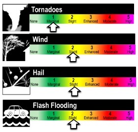
This line may include supercells and bow echoes capable of producing very large hail, strong winds to 70 mph and a few tornadoes, the weather service said. The highest tornado threat will be across the enhanced risk area near and shortly before sunset.
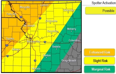
Wyandotte County and Greater Kansas City area in a “slight risk” area from 7 p.m. to midnight, according to the weather service. The main danger will be 65 mph winds, hail and a slight risk of isolated tornadoes, the weather service said. The flood threat may increase in this area.
Topeka, Kan., and St. Joseph, Mo., are in an “enhanced risk” area from 4 p.m. to 9 p.m., where the danger will include golf-ball sized hail and tornadoes.
Storms are expected to slowly weaken as they approach eastern portions of the slight risk area later in the evening, according to the weather service.
Today, there is a 40 percent chance of showers and thunderstorms, with a high near 79, the weather service said. A south wind of 7 to 14 mph will gust as high as 24 mph. Between a quarter and a half-inch of rain is possible.
Tonight, there is an 80 percent chance of showers and thunderstorms, mainly before midnight, according to the weather service. The low will be around 48. A south wind of 8 to 11 mph will become north northwest after midnight. Winds may gust as high as 25 mph. Between a half and three-quarters of an inch of new rainfall is possible.
Friday, it will be partly sunny, then gradually becoming sunny, with a high near 63, the weather service said. A north wind of 8 to 10 mph is possible.
Friday night, it will be clear with a low of 43, the weather service said. A north wind of 5 mph will become calm in the evening.
Saturday, the forecast is sunny with a high near 69, according to the weather service. A calm wind will become south around 6 mph in the afternoon.
Saturday night, it will be mostly clear with a low of 46, the weather service said.
For more weather information, visit www.weather.gov or http://www.weather.gov/eax/dss.


