Today, starting at 10 a.m., northbound I-435 will be reduced to one open lane from Kansas Avenue to just south of State Avenue so crews can switch traffic control from one side of the bridge to the other.
According to the Kansas Department of Transportation, this lane reduction will take place between 10 a.m. and 2 p.m. today, weather permitting.
Once the traffic control switch work is completed, the northbound I-435 to westbound I-70 ramp will reopen to unrestricted traffic by 3 p.m. today, weather permitting, according to KDOT.
Updated daily traffic information for this project and for the entire Kansas City Metro Area can be viewed at:www.ksdot.org/kcmetro/laneclose.asp.
The Kansas Department of Transportation urges all motorists to be alert, obey the warning signs, and slow down when approaching and driving through the project work zone.
Project work is scheduled to be completed in early October 2016, weather permitting.
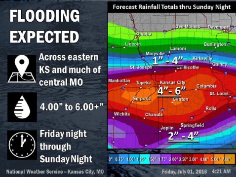
National Weather Service graphic
Several rounds of showers and thunderstorms are expected from tonight through Sunday night with widespread 4-6 inches of rain or more expected, the National Weather Service said.
Flash flooding and river flooding are likely, according to the weather service. A flash flood watch is in effect for Wyandotte County from 7 p.m. tonight through 4 a.m. July 4.
Isolated severe storms will be possible Saturday and Sunday with damaging winds and large hail the main threats, the weather service said.
The weather service said residents should monitor forecasts and be prepared to take action should a flash flood warning be issued.
Today, there is a 20 percent chance of showers and thunderstorms after 3 p.m., according to the weather service. The high will be near 81, with an east northeast wind of 6 to 9 mph.
Tonight, there is a 70 percent chance of showers and thunderstorms possible, mostly after 1 a.m. Some of the storms could produce heavy rainfall. The low will be 63, with an east wind of 3 to 7 mph.
Saturday, there is a 90 percent chance of showers and thunderstorms, and some of the storms could produce heavy rainfall, the weather service said. The high will be near 70 with an east wind of 8 to 15 mph, gusting to 21 mph. New rainfall amounts between 1 and 2 inches are possible.
Saturday night, the chance of showers and thunderstorms is 90 percent, according to the weather service. Some of the storms could produce heavy rainfall. The low is around 63, with and east wind of 5 to 11 mph. Between 1 and 2 inches of rain is possible.
Sunday, the chance of showers and thunderstorms is 70 percent, and they are likely before 1 p.m. Some of the storms could produce heavy rainfall, the weather service said. The high will be near 76, with a calm wind that changes to east northeast 5 to 7 mph in the morning. Between 1 and 2 inches of rain is possible.
Sunday night, the chance of showers and thunderstorms is 30 percent, according to the weather service. The low will be around 65. Between a quarter and half-inch of rain is possible.
On Monday, Independence Day, it will be mostly cloudy with a high near 81, the weather service said.
Monday night’s forecast is partly cloudy with a low of 67.
For more weather information, visit www.weather.gov or listen to a weather radio.