Kansas River in KCK under flood warning, along with Wyandotte County

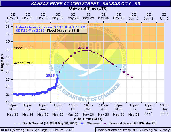
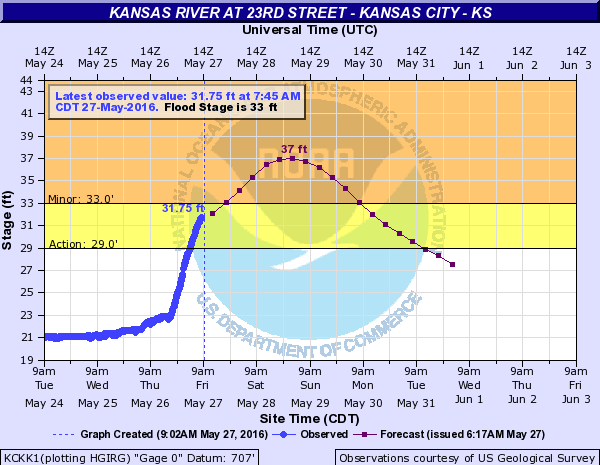
A hydrology chart  this morning shows the Kansas River at 23rd Street in Kansas City, Kan., entering the action stage and about ready to enter the minor flood stage of 33 feet. (NOAA chart)
A hydrology chart this morning shows the Kansas River at 23rd Street in Kansas City, Kan., entering the action stage and about ready to enter the minor flood stage of 33 feet. (NOAA chart)

The Kansas River at 23rd Street in Kansas City, Kan., is under a flood warning until 10 p.m. Friday, according to the National Weather Service.

All of Wyandotte County is under the flood warning, along with Leavenworth County and Johnson County, as well as counties on the Missouri side of the metropolitan area.

Residents are advised not to drive through flooded roads, but to turn around and go back.

As little as 6 inches of water may cause you to lose control of your vehicle, the weather service said. Two feet of water will carry most vehicles away.

The Board of Public Utilities outage map, as of 9:40 a.m. Friday, showed about 880 customers without power in Kansas City, Kan.

While morning hours will be quiet, it is possible that Wyandotte County could get another round or two of strong thunderstorms this afternoon, continuing through this evening, the weather service said.

The main concern of the storms will be the threat of additional river and flash flooding, according to the weather service.

A few strong or isolated severe storms are possible Saturday, while Sunday looks dry, the weather service said.

Thunderstorm chances will increase Monday through Wednesday.

Today, the high will be near 75, with a south wind of 8 to 13 mph, the weather service said. Showers and thunderstorms are likely after 1 p.m. There is a 70 percent chance of precipitation.

Tonight, the chance of precipitation is 80 percent, with showers and thunderstorms likely before 1 a.m., the weather service said. The low will be 60 with a south wind of 9 mph.

Saturday, it will be partly sunny with a high near 78 and a south wind of 7 to 10 mph, the weather service said. There is a 30 percent chance of showers and thunderstorms.

Saturday night, expect partly cloudy skies with a low of 61, according to the weather service.

Sunday, it will be mostly sunny with a high near 83 and a west southwest wind of 5 mph becoming calm in the afternoon.

Sunday night, the forecast is mostly cloudy with a low of 63, the weather service said.

Monday, Memorial Day, there is a 40 percent chance of showers and thunderstorms with a high near 81, the weather service said.

Monday night, expect a 40 percent chance of showers and thunderstorms, with a low of 63, according to the weather service.

Future hydrology chart projections could change and the river level predictions could be different later.

For more information, visit www.weather.gov/kc/ or listen to a weather radio.
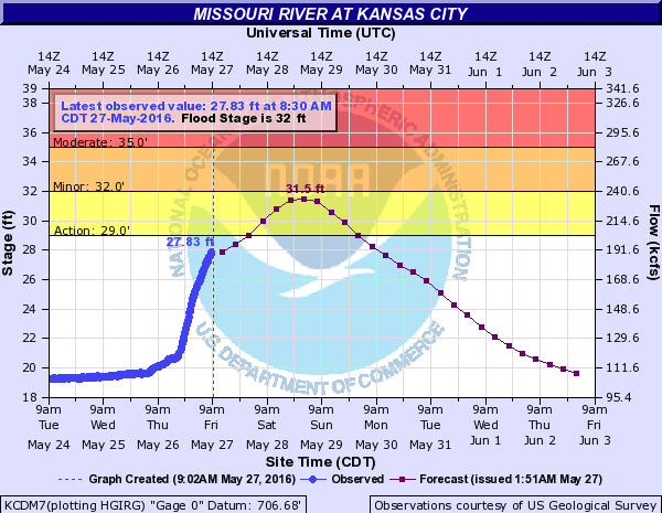
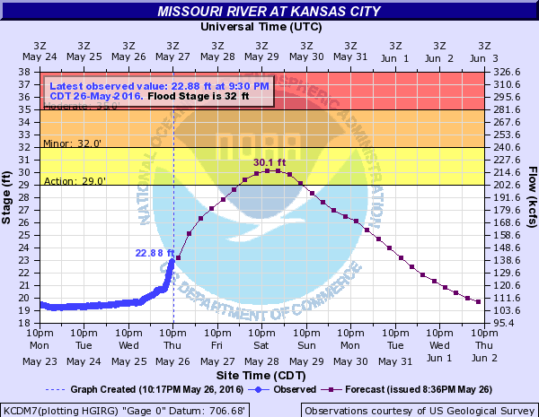
The Missouri River at Kansas City is almost ready to enter the action stage, It was at 27.83 feet on Friday morning, and flood stage is 32 feet. (NOAA chart)

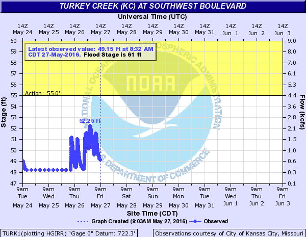
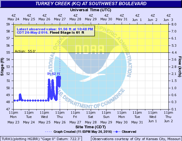
Turkey Creek was still under action stage as of Friday morning. (NOAA chart)

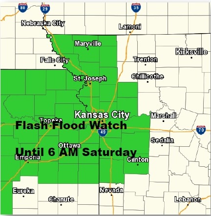
Flash flood watch today through Saturday. (National Weather Service graphic)

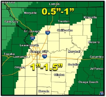
New rainfall through tonight (National Weather Service graphic)

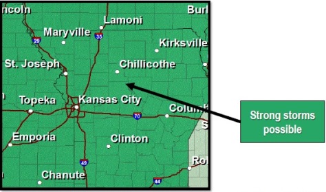
Friday's severe threat (National Weather Service graphic)
Friday’s severe threat (National Weather Service graphic)

Some northeast Kansas roads closed because of flooding

Update: K-99 (Lyon County) from I-35 to Allen Road now closed to traffic because of flood waters over the roadway.

K-68 (Lyon County) in the city of Quenemo now closed to all traffic due to flood waters over the roadway.

K-116 (Atchison County) over the Delaware River in Arrington now closed to all traffic due to flood waters over the roadway.

An update of northeast Kansas roads closed because of flooding as of about 7:15 a.m. Friday:

– K-5 (Leavenworth County) over 7-Mile Creek was still closed to all traffic due to flood waters over the roadway.

– K-9 (Marshall County) from K-87 junction to two miles east NOW CLOSED to all traffic due to flood waters over the roadway.

– K-18 (Wabaunsee/Riley Counties) from K-99 junction to K-177 still closed to all traffic due to flood waters over the roadway.

– K-87 (Marshall County) from the K-9 junction south to the Village of Vliets now closed to all traffic due to flood waters over the roadway.

– K-92 (Leavenworth County) over Stranger Creek now closed to all traffic due to flood waters over the roadway.

– K-192 (Leavenworth County) over Stranger Creek in Easton still closed to all traffic due to flood waters over the roadway.

The roadways are not expected to reopen until sometime later tonight.

Drivers must use alternate routes. No marked detours provided. Drivers: Do not attempt to drive through flooded or high water on roadways. Turn around, go back in other direction.

Flood warning in effect for Wyandotte County

The National Weather Service has issued a flood warning for Wyandotte County until 10 p.m. Friday.

The flood warning also is in effect for Leavenworth County and Johnson County as well as Platte, Ray, Jackson and Clay counties in Missouri.

In addition, also under the flood warning are parts of Doniphan and Atchison counties in Kansas, and Clinton, Lafayette, Daviess, Andrew, Caldwell, DeKalb and Buchanan counties in Missouri.

At 9:54 p.m., officials reported multiple roads closed across the region due to thunderstorms with heavy rain, the weather service said.

Additional storms tonight could result in heavy rain causing more flash flooding, the weather service said.

Widespread rainfall amounts of one to two inches have fallen, and some local areas have received more than four inches of rain, according to the weather service.

Residents are advised to turn around and not try to go through water in roadways.

Be cautious at night when it is harder to recognize the dangers of flooding.

When driving on hills, there are hundreds of low water crossings that are potentially dangerous in heavy rain, the weather service said. Do not attempt to cross flooded roads and find an alternate route.

Report flooding to local law enforcement when you are able to do so safely, the weather service said.

A hydrology chart for the Kansas River in Kansas City, Kan.,  as of 10:30 p.m. Thursday. (NOAA chart)
A hydrology chart for the Kansas River in Kansas City, Kan., as of 10:30 p.m. Thursday. (NOAA chart)

A hydrology chart of the Missouri River at Kansas City as of 10:30 p.m. Thursday. (NOAA chart)

Turkey Creek about 10:48 p.m. on Thursday. (NOAA chart)