Tornado watch issued through 7 p.m. Sunday

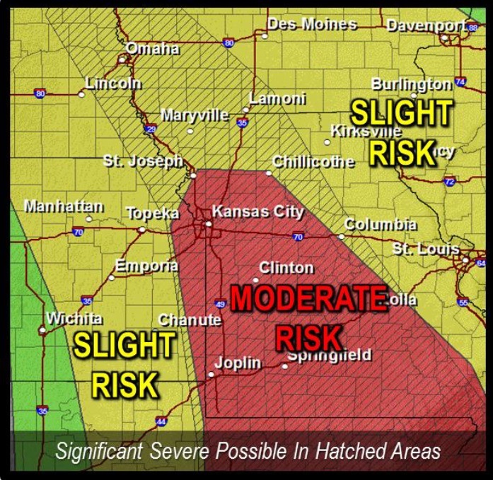
National Weather Service graphic

The National Weather Service has issued a tornado watch from 11:25 a.m. to 7 p.m. Sunday for Wyandotte County and the Kansas City area.

At 11 a.m., National Weather Service radar was tracking strong thunderstorms along a line extending from Lecompton to Paola, moving northeast at 75 mph.

The thunderstorm arrived in the center of Wyandotte County around 11:30 a.m.

Hail up to the size of nickels and wind gusts up to 50 mph are expected with these storms, along with heavy rains.

Bonner Springs, Edwardsville and other areas of Wyandotte County were in the path of the storm.

Residents are advised to monitor local media for updated information and possible warnings from the National Weather Service.

Torrential rain may flood low-lying areas such as ditches and underpasses. Do not drive into a flooded roadway, the weather service said.



Tornadoes, hail, wind possible Sunday

Thunderstorms are possible early Sunday morning in the region, mainly to the west and north St. Joseph, Mo., the National Weather Service said.

A few of the storms may produce hail up to 1 in in diameter.

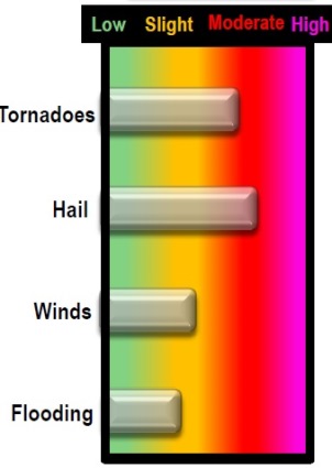
Numerous thunderstorms are expected to move into the area through the early and mid afternoon hours. These thunderstorms have the potential to produce widespread severe weather with tornadoes, very large hail and scattered damaging wind gusts, the weather service said.

There is a slight chance for a third round of strong to severe thunderstorms to develop near the Kansas-Missouri line near sunset and spreading to Missouri through the evening. It is ot clear if these storms will develop, but if they do they will be capable fo producing large hail and damaging winds, according to the weather service.

The first round of storms early in the morning, 5 a.m. to 10 a.m., should affect areas primarily north and west of St. Joseph, Mo. Large hail is the main threat.

Round two is expected to develop early this afternoon, from noon to 4 p.m., and will be the main round of storms capable of producing significant severe weather, including, several tornadoes, some intense; widespread large hail, some up to baseball size; scattered damaging winds, some up to hurricane force; and areas of minor flooding.

A possible third round of storms could develop later this evening over far eastern Kansas and sestern Missouri. It is not clear if these storms will develop, but if they do the storms will be capable of large hail and damaging winds, spreading into central Missouri through 11 p.m.

For the latest weather, visit www.weather.gov.

Severe storms in Sunday’s forecast; some rain possible Saturday

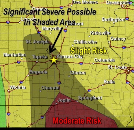
Severe storms possible Sunday. (National Weather Service graphic)

Showers and thunderstorms are possible before noon Saturday.

Some may produce small hail, according to the National Weather Service. The storms Saturday morning are not expected to be severe.

Tonight and Sunday, a powerful storm system will move into the area.
Two or three rounds of thunderstorms are possible, beginning as early as sunrise Sunday and lasting into Sunday evening.

The potential exists for strong to severe thunderstorms through the day Sunday with large hail, damaging winds and a few tornadoes.

Significant severe weather, including large hail and strong tornadoes, is possible, but this is still uncertain, the weather service said.