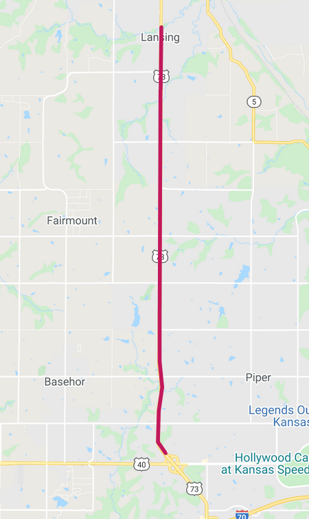
Intermittent lane closures are planned this week on U.S. 73. (KDOT map)
Lane closures for milling and overlay on U.S. 73 are occurring this week, according to the Kansas Department of Transportation.
The intermittent lane closures will be on U.S. 73 from State Avenue in Kansas City, Kansas, to Ida Street in Lansing from 6:30 p.m. to 6 p.m. Monday, June 15, through Friday, June 19.
Traffic on these projects may be diverted using mobile lane closures, signs and traffic cones, according to a KDOT spokesman.
KDOT urged all motorists to be alert and obey the warning signs when approaching and driving through a highway work zone, the spokesman stated. To stay aware of all road construction projects across Kansas go to www.kandrive.org or call 5-1-1. Motorists were urged to drive safely and always wear their seat belts, according to the spokesman.
A burglary was reported at 7:11 a.m. June 15 in the 5400 block of Kansas Avenue, according to a social media post by the Kansas City, Kansas, Police Department.
A suspect broke into three enclosed trailers and took property, according to the report.
Assault reported on North 10th Street
Aggravated assault was reported at 12:11 p.m. June 15 in the 100 block of North 10th Street, according to a social media post by the Kansas City, Kansas, Police Department.
A suspect stole property and then saw the victim, according to the report. The suspect pointed a gun at the victim, the report stated.
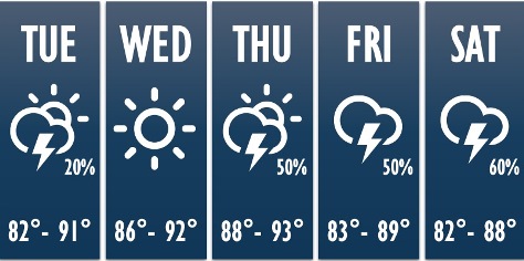
Temperatures could reach 90 today. (National Weather Service graphic)
Tuesday’s weather is much like Monday’s – just a few degrees lower, with a high near 90, according to the National Weather Service.
There is a 20 percent chance of showers and thunderstorms after 3 p.m., the weather service said. Most of the region will stay dry, however.
For the remainder of the week, there will be highs from the mid-80s to low-90s, according to the weather service. The humidity will be low, so it will feel like the air temperature.
Storm chances will return on Thursday through the weekend, the weather service said.
A cold front will move into the area and there will be increased chances for thunderstorms on Friday and Saturday, according to the weather service. The high will drop to 86 by Sunday.
Today, there is a 20 percent chance of showers and thunderstorms after 3 p.m., with a high near 90, the weather service said. There will be a south wind of 7 to 9 mph.
Tonight, there is a 30 percent chance of showers and thunderstorms before 7 p.m., with a low of 69, according to the weather service. A southeast wind will be around 10 mph. Less than a tenth of an inch of rain is possible.
Wednesday, it will be sunny with a high near 91 and a south wind of 9 to 13 mph, gusting as high as 20 mph, the weather service said.
Wednesday night, it will be mostly clear, with a low of 71 and a south southeast wind of 7 to 10 mph, according to the weather service.
Thursday, it will be mostly sunny, with a high near 93, the weather service said. A south wind of 6 to 10 mph will gust as high as 22 mph.
Thursday night, there is a 50 percent chance of showers, with thunderstorms also possible after 10 p.m., according to the weather service. The low will be around 71. Between a tenth and quarter-inch of rain is possible.
Friday, there is a 50 percent chance of showers and thunderstorms, with a high near 88, the weather service said.
Friday night, there is a 60 percent chance of showers and thunderstorms, mainly after 1 a.m., according to the weather service. The low will be around 71.
Saturday, there is a 60 percent chance of showers and thunderstorms, mainly after 1 p.m., the weather service said. The high will be near 87.
Saturday night, there is a 60 percent chance of showers and thunderstorms, with a low of 68, according to the weather service.