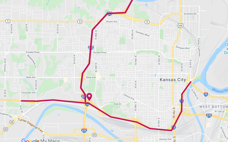
Ramp closures are planned Wednesday and Friday in Wyandotte County. (KDOT map)
Additional ramp and lane closures are scheduled in Wyandotte County, Wednesday, June 17, to Friday, June 19, according to the Kansas Department of Transportation, weather permitting.
Traffic on all these projects will be diverted using mobile lane closures, signs and traffic cones, according to a KDOT spokesman.
For pothole patching, the closures include:
• Alternating lane closures eastbound and westbound I-70 from 61st Street to the Missouri state line. • Alternating lane closures northbound and southbound I-635 from I-70 to the Missouri state line. Work on both projects will occur Wednesday, June 17, from 9 a.m. to 3 p.m.
For bridge joint maintenance, the closures include: • Ramp closure on westbound I-70 to southbound I-635, Thursday, June 18, to Friday, June 19, from 9 a.m. to 3 p.m.
The KDOT spokesman urged all motorists to be alert and obey the warning signs when approaching and driving through a highway work zone. To stay aware of all road construction projects across Kansas go to www.kandrive.org or call 5-1-1. Motorists should drive safely and always wear their seat belts, according to the spokesman.
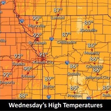
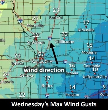
Today’s high will be near 90, according to the National Weather Service. (National Weather Service graphic)The temperature was 76 degrees at 8 a.m. in Wyandotte County, with a heat index of 78. Today’s high is expected to be near 90. Today will be the best day to do yard work in the next few days, if residents stay hydrated and stay away from the hottest time of day. (National Weather Service graphic)A south wind of 10 to 14 mph, will gust as high as 20 mph today. (National Weather Service graphic)
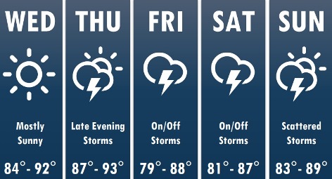
Warmer temperatures continue today and Thursday, according to the National Weather Service forecast.
Today’s high will be near 90, with winds gusting as high as 20 mph. Humidity will stay on the lower side, so it will feel very close to the air temperature, the weather service said.
Storms will return late Thursday evening, according to the weather service. Storm chances will move from the northwest toward the south and east through the overnight hours.
No severe weather is expected, but a few strong storms are possible, according to the weather service.
Storm chances continue intermittently on Friday and Saturday, with no severe weather expected, the weather service said.
Storm chances will linger for the beginning of next week, according to the weather service.
Today, it will be sunny with a high near 90 and a south wind of 10 to 14 mph, gusting as high as 20 mph, the weather service said.
Tonight, it will be clear with a low of 71 and a south southeast wind of 10 to 14 mph, gusting as high as 20 mph, according to the weather service.
Thursday, it will be sunny, with a high near 92 and a south wind of 10 to 14 mph, gusting as high as 22 mph, the weather service said.
Thursday night, there is a 60 percent chance of showers and thunderstorms, mainly after 1 a.m., according to the weather service. The low will be around 71 with a south wind of 5 to 7 mph becoming calm after midnight. Between a quarter and half of an inch of rain is possible.
Friday, there is a 60 percent chance of showers and thunderstorms, mainly before 1 p.m., the weather service said. The high will be near 83 with a light west southwest wind. Between a tenth and quarter-inch of rain is possible.
Friday night, there is a 70 percent chance of showers and thunderstorms, mainly after 1 a.m., according to the weather service. The low will be around 68. Between a tenth and quarter-inch of rain is possible.
Saturday, there is a 70 percent chance of showers and thunderstorms, with a high near 85, the weather service said.
Saturday night, there is a 50 percent chance of showers and thunderstorms, with a low of 66, according to the weather service.
Sunday, there is a 40 percent chance of showers and thunderstorms, with a high near 89, the weather service said.
Sunday night, there is a 30 percent chance of showers and thunderstorms, with a low of 69, according to the weather service.
Monday, there is a 30 percent chance of showers and thunderstorms, with a high near 91, the weather service said.
Monday night, there is a 30 percent chance of showers and thunderstorms, with a low of 70, according to the weather service.
Tuesday, there is a 30 percent chance of showers and thunderstorms, with a high near 90, the weather service said.
The victim of a fatal accident at 12:15 a.m. Sunday, June 14, at 10th and Parallel has been identified.
The man who died was Myron Gardner, 42, of Kansas City, Kansas, according to a spokesman with the Kansas City, Kansas, Police Department.
Gardner was driving a four-door sedan that was crossing Parallel Parkway northbound at 10th Street when it was struck by a sport utility vehicle, according to police.
There were three adults and two juveniles in the sedan, while there were two adults in the SUV.
The driver of the SUV fled on foot, but later turned herself in to police, the spokesman stated. Kendra K. Womack, 25, of Kansas City, Kansas, is being held in the Wyandotte County Jail on charges of failure to stop at an accident that resulted in a death, a police spokesman stated. Bond was set at $100,000.
The accident is being investigated by the Kansas City, Kansas, Police Department’s Traffic Support Unit – Critical Collision Response Team, the spokesman stated.