An Iowa man died of his injuries in a motorcycle accident at 5:10 p.m. Aug. 19 on I-70 near I-435 in Wyandotte County, according to a Kansas Highway Patrol trooper’s report.
Charles A. Geertz, 63, of Muscatine, Iowa, was on the ramp from southbound I-435 to eastbound I-70 when his Harley-Davidson went off the road for an unknown reason into the right ditch, according to the trooper’s report.
The motorcycle came back onto the road, went back off, came back on, then went off again, the trooper’s report stated.
The driver was still unable to regain control, and the motorcycle started to go into a sideways yaw, according to the trooper’s report.
The driver was unable to recover and hit a large rock In the ditch, the report stated. The bike vaulted, the front tire struck a bridge pillar about 6.5 feet up and came down on its side, according to the report.
The driver landed between the motorcycle and the bridge pillar, the report stated.
The driver was taken to a hospital, where he later died, according to the report.
A fire at 9:57 p.m. Aug. 20 caused $20,000 damage to a residence at 636 Freeman Court, according to a spokesman for the Kansas City, Kansas, Fire Department.
The fire at the two-story multifamily dwelling is under investigation, the spokesman stated. The cause is undetermined.
Fire crews saw flames showing from a second-floor apartment window when they arrived, according to the spokesman.
The fire was quickly extinguished and crews searched for hot spots. A primary and secondary search was completed.
There were no injuries to firefighters or civilians, the spokesman stated. The Red Cross was called for one person.
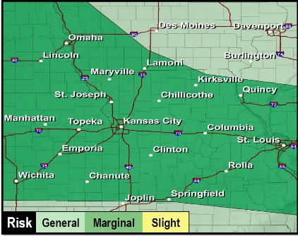
Wyandotte County is at a marginal risk for severe weather from today through Thursday, according to the National Weather Service. (National Weather Service graphic)
Thunderstorms will be ongoing this morning across the region, according to the National Weather Service.
The main risk for these storms will be flash flooding, the weather service said.
Thunderstorms will persist far north in the region, then spread south into eastern Kansas and central Missouri tonight through Thursday.
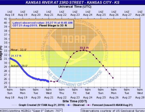
The Kansas River, at Kansas Avenue and the state line, could rise into minor flood stage on Saturday, according to hydrology charts. (National Weather Service – USGS graphic)
The Kansas River at 23rd Street, whose gauge is at Kansas Avenue and the state line, is projected to rise back into action stage on Thursday, and then into minor flood stage on Saturday morning, according to the weather service hydrology charts. The forecast crest is projected to reach 33.2 feet on Saturday, Aug. 24. Woodlands along the river may be flooded. No flooding of areas behind the levees is expected at this time.
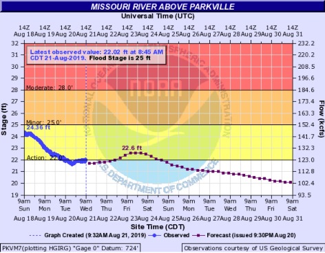
The Missouri River at Parkville, where the gauge includes Wyandotte County, is in action stage. (National Weather Service – USGS graphic)
The Missouri River at Parkville, where the gauge is on I-435 over the Missouri River between Wyandotte and Platte counties, has risen to action stage, according to hydrology charts, and is projected to continue below flood stage.
Today, there is a 50 percent chance of showers and thunderstorms, with a high near 87, the weather service said. Light and variable wind will become north northeast around 6 mph in the afternoon. Between a quarter and half-inch of rain is possible.
Tonight, there is a 70 percent chance of showers and thunderstorms, with a low of 67, according to the weather service. An east northeast wind of 6 to 8 mph is possible. Between 1 and 2 inches of rain are possible.
Thursday, there is a 70 percent chance of showers and thunderstorms likely, mainly before 2 p.m., the weather service said. The high will be near 79 with a northeast wind of 7 mph. Between a half and three-quarter inch of rain is possible.
Thursday night, there is a 50 percent chance of showers and thunderstorms, with a low of 67, according to the weather service. An east northeast wind of 6 mph will become calm in the evening. Between a half and three-quarter of an inch of rain is possible.
Friday, there is a 50 percent chance of showers and thunderstorms, mainly before 2 p.m., with a high near 79 and an east wnd of 3 to 6 mph, the weather service said. Between a half and three-quarters inch of rain is possible.
Friday night, there is a 20 percent chance of showers and thunderstorms before 8 a.m., then a slight chance of showers and thunderstorms after 2 a.m., according to the weather service. The low will be 65.
Saturday, there is a 30 percent chance of showers and thunderstorms between 8 a.m. and 2 p.., with a high near 81, the weather service said.
Saturday night, it will be partly cloudy with a low of 67, according to the weather service.
Sunday, it will be mostly sunny with a high near 86, the weather service said.
Sunday night, there is a 30 percent chance of showers and thunderstorms after 2 a.m., with a low of 72, according to the weather service.
Monday, there is a 30 percent chance of showers and thunderstorms, with a high near 86, the weather service said.
Monday night, there is a 40 percent chance of showers and thunderstorms, with a low of 69, according to the weather service.
Tuesday, there is a 40 percent chance of showers and thunderstorms, with a high near 84, the weather service said.
For more weather information, visit www.weather.gov.